

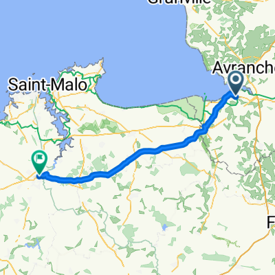
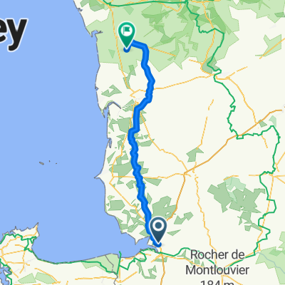
Courtils - Ducey - Avranches - Courtils
A cycling route starting in Le Val-Saint-Père, Normandy, France.
Overview
About this route
A challenging day tour along the bay of Le Mont-Saint-Michel, then along a cycle path (old railway line) to Ducey, offering a great opportunity to rest and a brief visit to the town. Then a hilly, normally trafficked road leads to Avranches. Here, it is worthwhile to visit the Jardin des Plantes with a stunning view of Le Mont-Saint-Michel and a visit to the Scriptorial d'Avranches. As a 'reward', a fast descent from the elevated town of Avranches back down to sea level and a relaxing return ride to Courtils.
- -:--
- Duration
- 36.7 km
- Distance
- 266 m
- Ascent
- 267 m
- Descent
- ---
- Avg. speed
- ---
- Max. altitude
Route quality
Waytypes & surfaces along the route
Waytypes
Road
22.4 km
(61 %)
Quiet road
5.1 km
(14 %)
Surfaces
Paved
16.9 km
(46 %)
Unpaved
3.7 km
(10 %)
Asphalt
16.9 km
(46 %)
Gravel
3.7 km
(10 %)
Undefined
16.2 km
(44 %)
Route highlights
Points of interest along the route
Point of interest after 14.6 km
Tolle Gelegenheit für eine Rast beim Schloss Ducey
Point of interest after 23.8 km
http://www.avranches.fr/Environnement/Jardin-des-plantes
Point of interest after 24.5 km
http://www.scriptorial.fr/#close
Accommodation after 36.7 km
http://www.campingsaintmichel.com/
Continue with Bikemap
Use, edit, or download this cycling route
You would like to ride Courtils - Ducey - Avranches - Courtils or customize it for your own trip? Here is what you can do with this Bikemap route:
Free features
- Save this route as favorite or in collections
- Copy & plan your own version of this route
- Sync your route with Garmin or Wahoo
Premium features
Free trial for 3 days, or one-time payment. More about Bikemap Premium.
- Navigate this route on iOS & Android
- Export a GPX / KML file of this route
- Create your custom printout (try it for free)
- Download this route for offline navigation
Discover more Premium features.
Get Bikemap PremiumFrom our community
Other popular routes starting in Le Val-Saint-Père
 De Résidence des Chênes 13, Le Val-Saint-Père à L'Abbaye 1, Le Mont-Saint-Michel
- Distance
- 23.2 km
- Ascent
- 102 m
- Descent
- 98 m
- Location
- Le Val-Saint-Père, Normandy, France
 Courtils - Ducey - Avranches - Courtils
- Distance
- 36.7 km
- Ascent
- 266 m
- Descent
- 267 m
- Location
- Le Val-Saint-Père, Normandy, France
 Nor10 MontSt Michel a Dinan
- Distance
- 59.3 km
- Ascent
- 250 m
- Descent
- 200 m
- Location
- Le Val-Saint-Père, Normandy, France
 Atlantic-Route 19. Etappe Saint-Grégoire - Saint Malo
- Distance
- 61.3 km
- Ascent
- 291 m
- Descent
- 317 m
- Location
- Le Val-Saint-Père, Normandy, France
 Day 3
Day 3- Distance
- 54.8 km
- Ascent
- 333 m
- Descent
- 139 m
- Location
- Le Val-Saint-Père, Normandy, France
 SanMichael
- Distance
- 21.6 km
- Ascent
- 27 m
- Descent
- 24 m
- Location
- Le Val-Saint-Père, Normandy, France
 Avranches - Périers
- Distance
- 82.7 km
- Ascent
- 797 m
- Descent
- 800 m
- Location
- Le Val-Saint-Père, Normandy, France
 stage servon 50
- Distance
- 55.8 km
- Ascent
- 362 m
- Descent
- 305 m
- Location
- Le Val-Saint-Père, Normandy, France
Open it in the app