1350 Flat Top Mesa Dr, Mesquite to 1173 Clouds Rest Pt, Mesquite
- 0.9 km
- 21 m
- 32 m
- Mesquite, Nevada, United States
A cycling route starting in Mesquite, Nevada, United States.
Overview
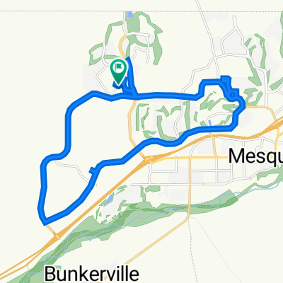
This rides starts at the corner of Flat Top Mesa Drive and Falcon Ridge Parkway; continues generally South through the two roundabouts, then jogs right off the second roundabout onto West Mesquite Boulevard; the ride continues East on West Mesquite Boulevard to a left (North) turn onto South Sandhill Boulevard; riders continue on South Sandhill Boulevard a short distance to a right (North) turn onto East Old Mill Road; almost immediately, riders take a left turn into the shopping center parking lot and continue riding around the back of the Smith's grocery store to Hillside Drive; turning right onto Hillside Drive (old Highway 91), riders now ride up a steep hill into Arizona and continue to follow Highway 91 to Scenic Drive; turning right onto Scenic drive, riders cross the Virgin River and begin a steep (but short climb, then a gentle to climb all the way to Elbow Canyon Road; turning right riders follow Elbow Canyon Road until the asphalt pavement ends; there the riders turn around and head back into Mesquite following the same route, this time enjoying very nice down hills and flats to just short of the Arizona border; then a short steep climb into Nevada and continuing to the Smith's parking lot, where the riders again ride behind the store to East Old Mill Road; the ride continues by turning right onto East Old Mill Road and riding to the intersection of West Mesquite Boulevard, where the riders turn right; West Mesquite Boulevard is ridden West, then jogging right through both roundabouts onto Falcon Ridge Parkway; the ride ends by following Falcon Ridge Parkway up hill back to the intersection of Flat Top Mesa Drive and Falcon Ridge Parkway. Total Ride Distance: 29.8 Miles.
Notes: 1. If you open the route in Google Roadmap or Google Hybrid (pulled down from the "Relief Map" tab) you will get a more up-to-date view of the roads and paths. Some of the other maps are dated. 2. This mapping program tends to under-compute the total ride mileage by roughly 10%, based on mileage for this ride when it has been actually ridden.created this 10 years ago
Route quality
Road
28.8 km
(60 %)
Quiet road
2.9 km
(6 %)
Paved
22 km
(46 %)
Asphalt
22 km
(46 %)
Undefined
25.9 km
(54 %)
Continue with Bikemap
You would like to ride Sun City Bike Club Hard Ride 2 Out and Back Through Scenic Arizona or customize it for your own trip? Here is what you can do with this Bikemap route:
Free trial for 3 days, or one-time payment. More about Bikemap Premium.
Discover more Premium features.
Get Bikemap PremiumFrom our community
Open it in the app