

Sun City Bike Club Easy Ride 3 (Tannery Cove)
A cycling route starting in Mesquite, Nevada, United States.
Overview
About this route
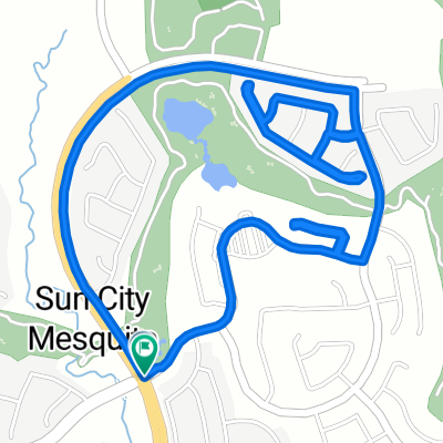
This very short ride starts at the corner of Flat Top Mesa Drive and Falcon Ridge Parkway, heads to and through Tannery Cove, then passed the Sun City Recreation Center and Sales Office and down the hill back to the beginning point. There are some short up hills and down hills on this ride. Total Ride Distance: 4.5 Miles.
Notes: 1. If you open the route in Google Roadmap or Google Hybrid (pulled down from the "Relief Map" tab) you will get a more up-to-date (but still not a completely accurate) view of the roads and paths. Some of the other maps are dated. 2. This mapping program tends to under-compute the total ride mileage by roughly 10%, based on mileage for this ride when it has been actually ridden.- -:--
- Duration
- 4.5 km
- Distance
- 116 m
- Ascent
- 116 m
- Descent
- ---
- Avg. speed
- ---
- Max. altitude
Route quality
Waytypes & surfaces along the route
Waytypes
Quiet road
3 km
(67 %)
Road
1.5 km
(33 %)
Surfaces
Paved
2.9 km
(64 %)
Asphalt
2.9 km
(64 %)
Undefined
1.6 km
(36 %)
Continue with Bikemap
Use, edit, or download this cycling route
You would like to ride Sun City Bike Club Easy Ride 3 (Tannery Cove) or customize it for your own trip? Here is what you can do with this Bikemap route:
Free features
- Save this route as favorite or in collections
- Copy & plan your own version of this route
- Sync your route with Garmin or Wahoo
Premium features
Free trial for 3 days, or one-time payment. More about Bikemap Premium.
- Navigate this route on iOS & Android
- Export a GPX / KML file of this route
- Create your custom printout (try it for free)
- Download this route for offline navigation
Discover more Premium features.
Get Bikemap PremiumFrom our community
Other popular routes starting in Mesquite
 Sun City Bike Club Easy Ride 3 (Tannery Cove)
- Distance
- 4.5 km
- Ascent
- 114 m
- Descent
- 114 m
- Location
- Mesquite, Nevada, United States
 870 Deep Gorge Trail, Mesquite to 1350 Flat Top Mesa Dr, Mesquite
- Distance
- 27.3 km
- Ascent
- 281 m
- Descent
- 243 m
- Location
- Mesquite, Nevada, United States
 Sun City Bike Club Easy Ride 4 (Wagon Wheel, Overland Trail and Frontier Pass Neighborhoods)
- Distance
- 5 km
- Ascent
- 91 m
- Descent
- 89 m
- Location
- Mesquite, Nevada, United States
 Mesquite, NV - Dolan Springs, NV
- Distance
- 238.4 km
- Ascent
- 1,600 m
- Descent
- 1,046 m
- Location
- Mesquite, Nevada, United States
 Mesquite, NV - Mount Charleston, NV
- Distance
- 182.8 km
- Ascent
- 2,261 m
- Descent
- 464 m
- Location
- Mesquite, Nevada, United States
 Settlers Way, Mesquite to 1350 Flat Top Mesa Dr, Mesquite
- Distance
- 15.1 km
- Ascent
- 232 m
- Descent
- 194 m
- Location
- Mesquite, Nevada, United States
 Recovered Route
- Distance
- 12.1 km
- Ascent
- 278 m
- Descent
- 231 m
- Location
- Mesquite, Nevada, United States
 Cycle-a-thon for Cancer
- Distance
- 16.3 km
- Ascent
- 132 m
- Descent
- 162 m
- Location
- Mesquite, Nevada, United States
Open it in the app