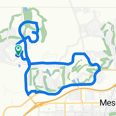
Sun City Bike Club Easy Ride 4 (Wagon Wheel, Overland Trail and Frontier Pass Neighborhoods)
A cycling route starting in Mesquite, Nevada, United States.
Overview
About this route
This ride starts at the corner of Flat Top Mesa Drive and Falcon Ridge Parkway and rides through the Sun City neighborhoods of Wagon Trail, Overland Trail and Frontier Pass. This ride does have some steep but short hills. Let's support each other up these hills! Walk your bike if you must knowing there is no shame - these are tough climbs! Know that the last leg of your ride will reward your hard work with a nice downhill.  Total Ride Distance: 3.1 Miles.
Notes: 1. If you open the route in Google Roadmap or Google Hybrid (pulled down from the "Relief Map" tab) you will get a more up-to-date (but still not a completely accurate) view of the roads and paths. Some of the other maps are dated. 2. This mapping program tends to under-compute the total ride mileage by roughly 10%, based on mileage for this ride when it has been actually ridden. - -:--
- Duration
- 5 km
- Distance
- 88 m
- Ascent
- 91 m
- Descent
- ---
- Avg. speed
- ---
- Max. altitude
Route quality
Waytypes & surfaces along the route
Waytypes
Quiet road
4.3 km
(87 %)
Road
0.7 km
(13 %)
Undefined
0 km
(<1 %)
Surfaces
Paved
0.7 km
(13 %)
Asphalt
0.7 km
(13 %)
Undefined
4.3 km
(87 %)
Continue with Bikemap
Use, edit, or download this cycling route
You would like to ride Sun City Bike Club Easy Ride 4 (Wagon Wheel, Overland Trail and Frontier Pass Neighborhoods) or customize it for your own trip? Here is what you can do with this Bikemap route:
Free features
- Save this route as favorite or in collections
- Copy & plan your own version of this route
- Sync your route with Garmin or Wahoo
Premium features
Free trial for 3 days, or one-time payment. More about Bikemap Premium.
- Navigate this route on iOS & Android
- Export a GPX / KML file of this route
- Create your custom printout (try it for free)
- Download this route for offline navigation
Discover more Premium features.
Get Bikemap PremiumFrom our community
Other popular routes starting in Mesquite
- 870 Deep Gorge Trail, Mesquite to 1350 Flat Top Mesa Dr, Mesquite
- Distance
- 27.3 km
- Ascent
- 281 m
- Descent
- 243 m
- Location
- Mesquite, Nevada, United States
- Sun City Bike Club Easy Ride 2 Out and Back Around Mesquite (With Some Climbs)
- Distance
- 20.1 km
- Ascent
- 81 m
- Descent
- 82 m
- Location
- Mesquite, Nevada, United States
- Mesquite, NV - Dolan Springs, NV
- Distance
- 238.4 km
- Ascent
- 1,600 m
- Descent
- 1,046 m
- Location
- Mesquite, Nevada, United States
- Cycle-a-thon for Cancer
- Distance
- 16.3 km
- Ascent
- 132 m
- Descent
- 162 m
- Location
- Mesquite, Nevada, United States
- Mesquite, NV - Mount Charleston, NV
- Distance
- 182.8 km
- Ascent
- 2,261 m
- Descent
- 464 m
- Location
- Mesquite, Nevada, United States
- Settlers Way, Mesquite to 1350 Flat Top Mesa Dr, Mesquite
- Distance
- 15.1 km
- Ascent
- 232 m
- Descent
- 194 m
- Location
- Mesquite, Nevada, United States
- Crescent Moon Crossing 830, Mesquite to Crescent Moon Bend 829, Mesquite
- Distance
- 3.4 km
- Ascent
- 44 m
- Descent
- 45 m
- Location
- Mesquite, Nevada, United States
- Sun City Bike Club Easy Ride 4 (Wagon Wheel, Overland Trail and Frontier Pass Neighborhoods)
- Distance
- 5 km
- Ascent
- 91 m
- Descent
- 89 m
- Location
- Mesquite, Nevada, United States
Open it in the app