

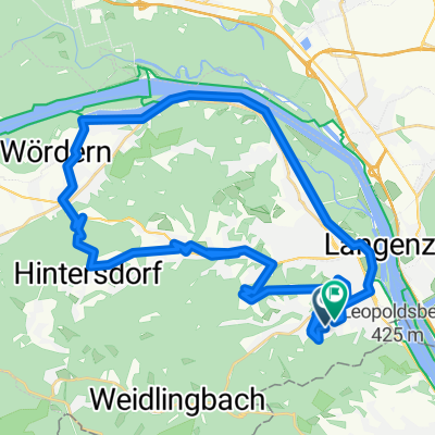
Klosterneuburg/Weidling - Nordbrücke - Greifenstein - Hadersfeld - Klosterneuburg/Weidling
A cycling route starting in Klosterneuburg, Lower Austria, Austria.
Overview
About this route
Initially, a pleasantly flat route along the Danube, good for warming up for the strenuous climb in Greifenstein towards Hadersfeld; the descent over the Ölberg provides the necessary cooling down, and the vineyard at the end can be easily managed even after 40 km of riding.
- -:--
- Duration
- 40.7 km
- Distance
- 369 m
- Ascent
- 368 m
- Descent
- ---
- Avg. speed
- ---
- Max. altitude
Continue with Bikemap
Use, edit, or download this cycling route
You would like to ride Klosterneuburg/Weidling - Nordbrücke - Greifenstein - Hadersfeld - Klosterneuburg/Weidling or customize it for your own trip? Here is what you can do with this Bikemap route:
Free features
- Save this route as favorite or in collections
- Copy & plan your own version of this route
- Sync your route with Garmin or Wahoo
Premium features
Free trial for 3 days, or one-time payment. More about Bikemap Premium.
- Navigate this route on iOS & Android
- Export a GPX / KML file of this route
- Create your custom printout (try it for free)
- Download this route for offline navigation
Discover more Premium features.
Get Bikemap PremiumFrom our community
Other popular routes starting in Klosterneuburg
 2020-05-18 1:39 Babenberger Strecke
- Distance
- 22.9 km
- Ascent
- 464 m
- Descent
- 465 m
- Location
- Klosterneuburg, Lower Austria, Austria
 B 6 7 18
- Distance
- 21.6 km
- Ascent
- 364 m
- Descent
- 364 m
- Location
- Klosterneuburg, Lower Austria, Austria
 gericht
- Distance
- 8.8 km
- Ascent
- 60 m
- Descent
- 170 m
- Location
- Klosterneuburg, Lower Austria, Austria
 Route in Klosterneuburg
- Distance
- 42.6 km
- Ascent
- 868 m
- Descent
- 870 m
- Location
- Klosterneuburg, Lower Austria, Austria
 Von Klosterneuburg bis Wien
- Distance
- 13 km
- Ascent
- 108 m
- Descent
- 203 m
- Location
- Klosterneuburg, Lower Austria, Austria
 KLBG-Dopplerhütte-Kreuzenstein
- Distance
- 78.1 km
- Ascent
- 694 m
- Descent
- 706 m
- Location
- Klosterneuburg, Lower Austria, Austria
 D LILIENFELD
- Distance
- 88.4 km
- Ascent
- 305 m
- Descent
- 157 m
- Location
- Klosterneuburg, Lower Austria, Austria
 Donau Slowakei
- Distance
- 184.5 km
- Ascent
- 451 m
- Descent
- 556 m
- Location
- Klosterneuburg, Lower Austria, Austria
Open it in the app