

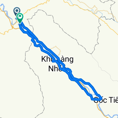
J067 - lundi 16 mars 2015 - Lang Khay - Lao Cai
A cycling route starting in Thị Trấn Phố Ràng, Lào Cai Province, Vietnam.
Overview
About this route
J067 - Monday, March 16, 2015 - Lang Khay - Lao Cai - 95.78 kms - average 11.52 kms/h - ascent elevation 1165 meters - max slope 12 % - descent elevation 1093 meters - max downhill slope 10 % - max altitude 388 meters - arrival altitude 56 meters.
- -:--
- Duration
- 93.8 km
- Distance
- 718 m
- Ascent
- 690 m
- Descent
- ---
- Avg. speed
- ---
- Max. altitude
Continue with Bikemap
Use, edit, or download this cycling route
You would like to ride J067 - lundi 16 mars 2015 - Lang Khay - Lao Cai or customize it for your own trip? Here is what you can do with this Bikemap route:
Free features
- Save this route as favorite or in collections
- Copy & plan your own version of this route
- Split it into stages to create a multi-day tour
- Sync your route with Garmin or Wahoo
Premium features
Free trial for 3 days, or one-time payment. More about Bikemap Premium.
- Navigate this route on iOS & Android
- Export a GPX / KML file of this route
- Create your custom printout (try it for free)
- Download this route for offline navigation
Discover more Premium features.
Get Bikemap PremiumFrom our community
Other popular routes starting in Thị Trấn Phố Ràng
 Pho Rang to Moa An
- Distance
- 19.7 km
- Ascent
- 520 m
- Descent
- 522 m
- Location
- Thị Trấn Phố Ràng, Lào Cai Province, Vietnam
 14 Pho Rang - Yen Binh
- Distance
- 88 km
- Ascent
- 589 m
- Descent
- 608 m
- Location
- Thị Trấn Phố Ràng, Lào Cai Province, Vietnam
 J067 - lundi 16 mars 2015 - Lang Khay - Lao Cai
- Distance
- 93.8 km
- Ascent
- 718 m
- Descent
- 690 m
- Location
- Thị Trấn Phố Ràng, Lào Cai Province, Vietnam
 Bao Ha to Lai Chau(by Route 279)
- Distance
- 147.7 km
- Ascent
- 2,742 m
- Descent
- 1,882 m
- Location
- Thị Trấn Phố Ràng, Lào Cai Province, Vietnam
 Day 13: Pho Rang - Viet Quang
- Distance
- 66 km
- Ascent
- 506 m
- Descent
- 489 m
- Location
- Thị Trấn Phố Ràng, Lào Cai Province, Vietnam
 ? Kiou Leou Ti - Bao Yen
- Distance
- 123 km
- Ascent
- 2,044 m
- Descent
- 1,775 m
- Location
- Thị Trấn Phố Ràng, Lào Cai Province, Vietnam
 Test
Test- Distance
- 76.4 km
- Ascent
- 382 m
- Descent
- 367 m
- Location
- Thị Trấn Phố Ràng, Lào Cai Province, Vietnam
 J071 - Vendredi 20 mars 2015 - Lang Pho Rang - Yen Bai
- Distance
- 91.4 km
- Ascent
- 416 m
- Descent
- 449 m
- Location
- Thị Trấn Phố Ràng, Lào Cai Province, Vietnam
Open it in the app