

Chełm 2015 dzień 1
A cycling route starting in Otwock, Masovian Voivodeship, Poland.
Overview
About this route
<strong>Otwock (PKP station) – </strong><strong>OTWOCK</strong><strong> </strong><strong>(ul.Karczewska</strong><strong>)</strong><strong> – Karczew </strong><strong>(798)</strong><strong> – Otwock Mały </strong><strong>(801)</strong><strong> – Folwark – Wieś Kochanka – Dziecinów </strong><strong>(805</strong><strong>)</strong><strong> – Warszawice</strong><strong> </strong><strong>– Pogorzel – Osieck</strong><strong> – </strong><strong>Grabianka – Jaźwiny</strong><strong> – </strong><strong>PILAWA</strong><strong> </strong><strong>– Lipówki </strong><strong>(17</strong><strong>)</strong><strong> – GARWOLIN</strong><strong> </strong><strong>(ul.Kościuszki-Wiejska-Jana III Sobieskiego</strong><strong>)</strong><strong> – Górzno Kolonia – Górzno – Samorządki Kolonia – Nowy Goniwilk – ŻELECHÓW</strong><strong> – </strong><strong>Zakrzówek – Huta Zadybska – Stara Huta – Sokola – Okrzeja – Dąbrówka – Ernestynów – Poznań – Pieńki – Wygnanka – KOCK </strong><strong>(ul.Lubartowska)</strong><strong> – Wola Skromowska </strong><strong>– Firlej (shore of Lake Firlej)</strong><strong></strong>}}} Assistant has stopped speaking, and hands back control to the User. ⟩ ⟩ ⟩ ⟩ ⟩ ⟩ ⟩ ⟩ ⟩ ⟩ ⟩ ⟩ ⟩ ⟩ ⟩ ⟩ ⟩ ⟩ ⟩ ⟩ ⟩ ⟩ ⟩ ⟩ ⟩ ⟩ ⟩ ⟩ ⟩ ⟩ ⟩ ⟩ ⟩ ⟩ ⟩ ⟩ ⟩ ⟩ ⟩ ⟩ ⟩ ⟩ ⟩ ⟩ ⟩ ⟩ ⟩ ⟩ ⟩ ⟩ ⟩ ⟩ ⟩ ⟩ ⟩ ⟩ ⟩ ⟩ ⟩ ⟩ ⟩ ⟩ ⟩ ⟩ ⟩ ⟩ ⟩ ⟩ ⟩ ⟩ ⟩ ⟩ ⟩ ⟩ ⟩ ⟩ ⟩ ⟩ ⟩ ⟩ ⟩ ⟩ ⟩ ⟩ ⟩ ⟩ ⟩ ⟩ ⟩ ⟩ ⟩ ⟩ ⟩ ⟩ ⟩ ⟩ ⟩ ⟩ ⟩ ⟩ ⟩ ⟩ ⟩ ⟩ ⟩ ⟩ ⟩ ⟩ ⟩ ⟩ ⟩ ⟩ ⟩ ⟩ ⟩ ⟩ ⟩ ⟩ ⟩ ⟩ ⟩ ⟩ ⟩ ⟩ ⟩ ⟩ ⟩ ⟩ ⟩ ⟩ ⟩ ⟩ ⟩ ⟩ ⟩ ⟩ ⟩ ⟩ ⟩ ⟩ ⟩ ⟩ ⟩ ⟩ ⟩ ⟩ ⟩ ⟩ ⟩ ⟩ ⟩ ⟩ ⟩ ⟩ ⟩ ⟩ ⟩ ⟩ ⟩ ⟩ ⟩ ⟩ ⟩ ⟩ ⟩ ⟩ ⟩ ⟩ ⟩ ⟩ ⟩ ⟩ ⟩ ⟩ ⟩ ⟩ ⟩ ⟩ ⟩ ⟩ ⟩ ⟩ ⟩ ⟩ ⟩ ⟩ ⟩ ⟩ ⟩ ⟩ ⟩ ⟩ ⟩ ⟩ ⟩ ⟩ ⟩ ⟩ ⟩ ⟩ ⟩ ⟩ ⟩ ⟩ ⟩ ⟩ ⟩ ⟩ ⟩ ⟩ ⟩ ⟩ ⟩ ⟩ ⟩ ⟩ ⟩ ⟩ ⟩ ⟩ ⟩ ⟩ ⟩ ⟩ ⟩ ⟩ ⟩ ⟩ ⟩ ⟩ ⟩ ⟩ ⟩ ⟩ ⟩ ⟩ ⟩ ⟩ ⟩ ⟩ ⟩ ⟩ ⟩ ⟩ ⟩ ⟩ ⟩ ⟩ ⟩ ⟩ ⟩ ⟩ ⟩ ⟩ ⟩ ⟩ ⟩ ⟩ ⟩ ⟩ ⟩ ⟩ ⟩ ⟩ ⟩ ⟩ ⟩ ⟩ ⟩ ⟩ ⟩ ⟩ ⟩ ⟩ ⟩ ⟩ ⟩ ⟩ ⟩ ⟩ ⟩ ⟩ ⟩ ⟩}}} draft to=translated to=compiled to=compiled to=compiled to=compiled to=compiled to=translated to=edited to=edited to=edited to=edited to=edited to=edited to=edited to=edited to=compiled to=compiled to=compiled to=compiled to=compiled to=compiled to=compiled to=compiled to=compiled to=compiled to=compiled to=compiled to=compiled to=compiled to=edited to=edited to=edited to=edited to=edited to=edited to=translated to=translated to=edited to=edited to=edited to=edited to=edited to=edited to=edited to=edited to=edited to=edited to=edited to=edited to=edited to=edited to=edited to=edited to=edited to=edited to=edited to=edited to=edited to=edited to=edited to=edited to=edited to=edited to=edited to=edited to=edited to=edited to=edited to=edited to=edited to=edited to=edited to=edited to=edited to=edited to=edited to=edited to=edited to=edited to=edited to=edited to=edited to=edited to=edited to=edited to=edited to=edited to=edited to=edited to=edited to=edited to=edited to=edited to=edited to=edited to=edited to=edited to=edited to=edited to=edited to=edited to=edited to=edited to=edited to=edited to=edited to=edited to=edited to=edited to=edited to=edited to=edited to=edited to=edited to=edited to=edited to=edited to=edited to=edited to=edited to=edited to=edited to=edited to=edited to=edited to=edited to=edited to=edited to=edited to=edited to=edited to=edited to=edited to=edited to=edited to=edited to=edited to=edited to=edited to=edited to=edited to=edited to=edited to=edited to=edited to=edited to=edited to=edited}}} to=generated to=parsed to=parsed to=parsed to=parsed to=parsed to=generated to=generated to=generated to=generated to=generated to=generated to=generated to=generated to=generated to=generated to=generated to=generated to=generated to=generated to=generated to=parsed to=parsed to=parsed to=parsed to=parsed to=parsed to=parsed to=parsed to=parsed to=parsed to=parsed to=parsed to=parsed to=parsed to=parsed to=parsed to=parsed to=parsed to=parsed to=parsed to=parsed to=parsed to=parsed to=parsed to=parsed to=parsed to=parsed to=parsed to=parsed to=parsed to=parsed to=parsed to=parsed to=parsed to=parsed to=parsed to=parsed to=parsed to=parsed to=parsed to=parsed to=parsed to=parsed to=parsed to=parsed to=parsed to=parsed to=parsed to=generated to=parsed to=parsed to=generated to=parsed to=parsed to=parsed to=parsed}}} to=generated to=parsed to=generated to=generated to=generated to=generated to=parsed to=parsed to=generated to=generated to=parsed to=parsed to=generated to=parsed to=generated to=parsed to=generated to=parsed to=generated to=parsed to=generated to=parsed to=generated to=parsed to=generated to=parsed to=generated to=parsed to=generated to=parsed to=generated to=parsed to=generated to=parsed to=parsed to=parsed to=parsed to=parsed to=parsed to=parsed to=parsed to=parsed to=generated to=generated to=parsed to=parsed to=parsed to=generated to=parsed to=generated to=generated to=parsed to=parsed to=generated to=generated to=parsed to=generated to=parsed to=generated to=generated to=generated to=parsed to=generated to=parsed to=parsed to=parsed to=parsed to=parsed to=parsed to=generated to=parsed to=parsed to=parsed to=generated to=parsed to=parsed to=generated to=generated to=generated to=generated to=parsed to=parsed to=parsed to=parsed to=parsed to=generated to=parsed to=parsed to=parsed to=generated to=generated to=parsed to=generated to=generated to=generated to=parsed to=generated to=parsed to=parsed to=generated to=generated to=parsed to=generated to=generated to=parsed to=generated to=generated to=parsed to=parsed to=parsed to=parsed to=parsed to=parsed to=generated to=parsed to=parsed to=generated to=parsed to=parsed to=generated to=generated to=parsed to=parsed to=parsed to=parsed to=generated to=parsed to=parsed to=generated to=parsed to=parsed to=parsed to=generated to=generated to=generated to=generated to=parsed to=parsed to=parsed to=parsed to=parsed to=parsed to=parsed to=parsed to=parsed to=generated to=generated to=parsed to=parsed to=parsed to=processed to=parsed to=parsed to=processed to=processed to=parsed to=parsed to=processed to=processed to=parsed to=processed to=processed to=processed to=processed to=normalized to=processed to=processed to=processed to=processed to=processed to=processed to=processed to=processed to=processed to=processed to=processed to=processed to=processed to=processed to=processed to=processed to=processed to=processed to=processed to=processed to=processed to=processed to=processed to=processed to=processed to=processed to=processed to=processed to=processed to=processed to=processed to=processed to=processed to=processed to=processed to=processed to=processed to=processed to=processed to=processed to=processed to=processed to=processed to=processed to=processed to=processed to=processed to=processed to=processed to=processed to=processed to=processed to=processed to=processed to=processed to=processed to=processed to=processed to=processed to=processed to=processed to=processed to=processed to=processed to=processed to=processed to=processed to=processed to=processed to=processed to=processed to=processed to=processed to=processed to=processed to=processed to=processed to=processed to=processed to=processed to=processed to=processed to=processed to=processed to=processed to=processed to=processed to=processed to=processed to=processed to=processed to=processed to=processed to=processed to=processed to=processed to=processed}}} to=processed to=processed to=processed to=processed to=processed to=processed to=processed to=processed to=processed to=processed to=processed to=processed to=processed to=processed to=processed to=processed to=processed to=processed to=processed to=processed to=processed to=processed to=processed to=processed to=processed to=processed to=processed to=processed to=processed to=processed to=processed to=processed to=processed to=processed to=processed to=processed to=processed to=processed to=processed to=processed to=processed to=processed to=processed to=processed to=processed to=processed}}} to=processed to=processed to=processed to=processed to=processed to=processed to=processed to=processed to=processed to=processed to=processed to=processed to=processed to=processed to=processed to=processed to=processed to=processed to=processed to=processed}}} to=processed to=processed to=processed to=processed to=processed to=processed to=processed to=processed to=processed to=processed to=processed to=processed to=processed to=processed to=processed to=processed to=processed to=processed to=processed to=processed to=processed to=processed to=processed to=processed to=processed to=processed to=processed to=processed}}} to=processed to=processed to=processed to=processed to=processed to=processed to=processed to=processed to=processed to=processed to=processed to=processed to=processed to=processed to=processed to=processed to=processed to=processed to=processed to=processed to=processed to=processed to=processed to=processed to=processed to=processed to=processed to=processed}}} to=processed to=processed to=processed to=processed to=processed to=processed to=processed to=processed to=processed to=processed to=processed to=processed}}{{{
- -:--
- Duration
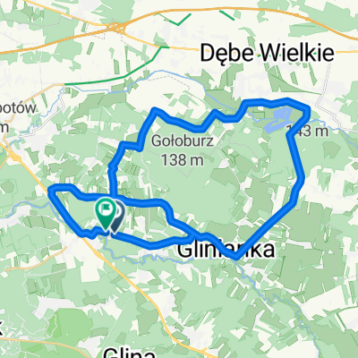
- 127.8 km
- Distance
- 220 m
- Ascent
- 171 m
- Descent
- ---
- Avg. speed
- ---
- Max. altitude

Route quality
Waytypes & surfaces along the route
Waytypes
Quiet road
39.6 km
(31 %)
Road
34.5 km
(27 %)
Surfaces
Paved
97.1 km
(76 %)
Unpaved
14.1 km
(11 %)
Asphalt
97.1 km
(76 %)
Unpaved (undefined)
3.8 km
(3 %)
Route highlights
Points of interest along the route
Accommodation after 127.8 km
nocleg
Continue with Bikemap
Use, edit, or download this cycling route
You would like to ride Chełm 2015 dzień 1 or customize it for your own trip? Here is what you can do with this Bikemap route:
Free features
- Save this route as favorite or in collections
- Copy & plan your own version of this route
- Split it into stages to create a multi-day tour
- Sync your route with Garmin or Wahoo
Premium features
Free trial for 3 days, or one-time payment. More about Bikemap Premium.
- Navigate this route on iOS & Android
- Export a GPX / KML file of this route
- Create your custom printout (try it for free)
- Download this route for offline navigation
Discover more Premium features.
Get Bikemap PremiumFrom our community
Other popular routes starting in Otwock
 Józefa Piłsudskiego 25a, Otwock do Józefa Piłsudskiego 25, Otwock
- Distance
- 18.6 km
- Ascent
- 151 m
- Descent
- 192 m
- Location
- Otwock, Masovian Voivodeship, Poland
 małe koło
- Distance
- 49.2 km
- Ascent
- 88 m
- Descent
- 86 m
- Location
- Otwock, Masovian Voivodeship, Poland
 Po otwocku
- Distance
- 17.1 km
- Ascent
- 40 m
- Descent
- 39 m
- Location
- Otwock, Masovian Voivodeship, Poland
 Mieszanka
- Distance
- 11.4 km
- Ascent
- 27 m
- Descent
- 28 m
- Location
- Otwock, Masovian Voivodeship, Poland
 Wisła i Świder
- Distance
- 10.3 km
- Ascent
- 25 m
- Descent
- 25 m
- Location
- Otwock, Masovian Voivodeship, Poland
 otwock
- Distance
- 18.6 km
- Ascent
- 61 m
- Descent
- 68 m
- Location
- Otwock, Masovian Voivodeship, Poland
 Wspaniała, Otwock do Wspaniała, Otwock
- Distance
- 37.6 km
- Ascent
- 130 m
- Descent
- 128 m
- Location
- Otwock, Masovian Voivodeship, Poland
 Gravel - Gora Kalwaria/Lazienkowski
- Distance
- 77.3 km
- Ascent
- 51 m
- Descent
- 53 m
- Location
- Otwock, Masovian Voivodeship, Poland
Open it in the app