

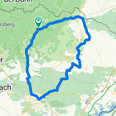
Biosphärenhaus
A cycling route starting in Lembach, Grand Est, France.
Overview
About this route
Lembach (OT - Location E-MTB + battery charging) - Camping du Fleckentein (E-MTB rental + battery charging) - D - Hirschthal - Schönau in der Pfalz - Biosphärenhaus (battery charging) - Saarbach-hammer - Schöntal-Weiher - Ludwigswinkel - Petersbaechel - Gebüg - Schönau in der Pfalz - Hirschtahl - F - Camping du Fleckenstein (E-MTB rental + battery charging) - Lembach.
- -:--
- Duration
- 37.5 km
- Distance
- 275 m
- Ascent
- 273 m
- Descent
- ---
- Avg. speed
- ---
- Max. altitude

Route quality
Waytypes & surfaces along the route
Waytypes
Quiet road
8.3 km
(22 %)
Road
5.3 km
(14 %)
Surfaces
Paved
33 km
(88 %)
Asphalt
29.3 km
(78 %)
Paved (undefined)
3.4 km
(9 %)
Continue with Bikemap
Use, edit, or download this cycling route
You would like to ride Biosphärenhaus or customize it for your own trip? Here is what you can do with this Bikemap route:
Free features
- Save this route as favorite or in collections
- Copy & plan your own version of this route
- Sync your route with Garmin or Wahoo
Premium features
Free trial for 3 days, or one-time payment. More about Bikemap Premium.
- Navigate this route on iOS & Android
- Export a GPX / KML file of this route
- Create your custom printout (try it for free)
- Download this route for offline navigation
Discover more Premium features.
Get Bikemap PremiumFrom our community
Other popular routes starting in Lembach
 C4 A la découverte de l'Outre-Forêt
- Distance
- 77.7 km
- Ascent
- 425 m
- Descent
- 424 m
- Location
- Lembach, Grand Est, France
 Niederbronn les Bains
- Distance
- 47 km
- Ascent
- 479 m
- Descent
- 479 m
- Location
- Lembach, Grand Est, France
 Ex - C 01 - Entre forêt et route du vin – 42 km
- Distance
- 42.6 km
- Ascent
- 569 m
- Descent
- 569 m
- Location
- Lembach, Grand Est, France
 C3 Circuit transfrontalier
- Distance
- 45.9 km
- Ascent
- 382 m
- Descent
- 382 m
- Location
- Lembach, Grand Est, France
 2012 French Tour -- Ride Day 23 -- 3 September 2012 -- Climbach -- Circle
- Distance
- 48.3 km
- Ascent
- 435 m
- Descent
- 433 m
- Location
- Lembach, Grand Est, France
 C2 Entre ville et forêt.
- Distance
- 78.6 km
- Ascent
- 418 m
- Descent
- 418 m
- Location
- Lembach, Grand Est, France
 VTT - Marienbronn
- Distance
- 17.1 km
- Ascent
- 415 m
- Descent
- 418 m
- Location
- Lembach, Grand Est, France
 Freundschafts-Tour
- Distance
- 30.4 km
- Ascent
- 706 m
- Descent
- 706 m
- Location
- Lembach, Grand Est, France
Open it in the app