

Lančov-Hardegg-Vranov nad Dyjí
A cycling route starting in Blížkovice, South Moravian, Czechia.
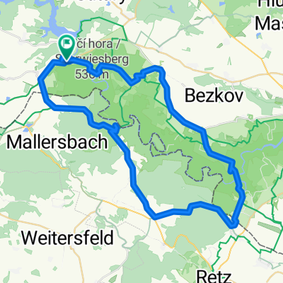
Overview
About this route
Trasa je středně těžká a vede přes
česko-rakouskou hranici národním parkem Podyjí.
- -:--
- Duration
- 28.2 km
- Distance
- 514 m
- Ascent
- 514 m
- Descent
- ---
- Avg. speed
- ---
- Max. altitude
Route highlights
Points of interest along the route
Point of interest after 4.3 km
Continue with Bikemap
Use, edit, or download this cycling route
You would like to ride Lančov-Hardegg-Vranov nad Dyjí or customize it for your own trip? Here is what you can do with this Bikemap route:
Free features
- Save this route as favorite or in collections
- Copy & plan your own version of this route
- Sync your route with Garmin or Wahoo
Premium features
Free trial for 3 days, or one-time payment. More about Bikemap Premium.
- Navigate this route on iOS & Android
- Export a GPX / KML file of this route
- Create your custom printout (try it for free)
- Download this route for offline navigation
Discover more Premium features.
Get Bikemap PremiumFrom our community
Other popular routes starting in Blížkovice
 Okolo Vranovské přehrady
- Distance
- 32.1 km
- Ascent
- 728 m
- Descent
- 714 m
- Location
- Blížkovice, South Moravian, Czechia
 Vranov nad Dyjí - Podhradí nad Dyjí - Vranov nad Dyjí
- Distance
- 30.8 km
- Ascent
- 434 m
- Descent
- 437 m
- Location
- Blížkovice, South Moravian, Czechia
 Vranov nad Dyjí, hrad Cornštejn, Zblovice
- Distance
- 40.5 km
- Ascent
- 494 m
- Descent
- 494 m
- Location
- Blížkovice, South Moravian, Czechia
 2025_Morva_3.nap
- Distance
- 37.2 km
- Ascent
- 683 m
- Descent
- 809 m
- Location
- Blížkovice, South Moravian, Czechia
 Vranov - vinice Šobes - Hardegg
- Distance
- 52.1 km
- Ascent
- 797 m
- Descent
- 796 m
- Location
- Blížkovice, South Moravian, Czechia
 Vranov nad Dyjí - Znojmo, pěšky
- Distance
- 29.7 km
- Ascent
- 387 m
- Descent
- 439 m
- Location
- Blížkovice, South Moravian, Czechia
 Lančov-Hardegg-Vranov nad Dyjí
- Distance
- 28.2 km
- Ascent
- 514 m
- Descent
- 514 m
- Location
- Blížkovice, South Moravian, Czechia
 Podyji MTB
- Distance
- 51.6 km
- Ascent
- 901 m
- Descent
- 903 m
- Location
- Blížkovice, South Moravian, Czechia
Open it in the app