

Col Saint-Pantaléon and Cervinia
A cycling route starting in Châtillon, Aosta Valley, Italy.
Overview
About this route
3
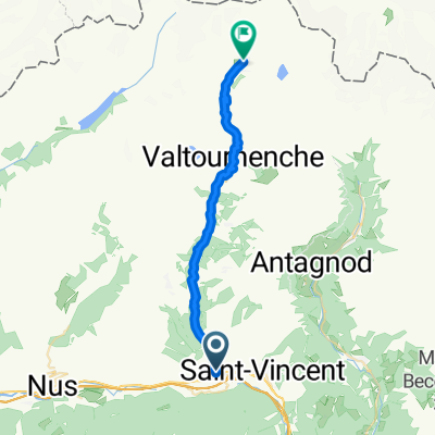
The last two climbs of stage 19 of the upcoming 2015 Giro d'Italia.
More details- -:--
- Duration
- 80 km
- Distance
- 2,160 m
- Ascent
- 2,156 m
- Descent
- ---
- Avg. speed
- ---
- Max. altitude
Will
created this 11 years ago
Route highlights
Points of interest along the route
Point of interest after 25.4 km
Col Saint-Pantaléon
Point of interest after 52.8 km
Cervinia
Continue with Bikemap
Use, edit, or download this cycling route
You would like to ride Col Saint-Pantaléon and Cervinia or customize it for your own trip? Here is what you can do with this Bikemap route:
Free features
- Save this route as favorite or in collections
- Copy & plan your own version of this route
- Sync your route with Garmin or Wahoo
Premium features
Free trial for 3 days, or one-time payment. More about Bikemap Premium.
- Navigate this route on iOS & Android
- Export a GPX / KML file of this route
- Create your custom printout (try it for free)
- Download this route for offline navigation
Discover more Premium features.
Get Bikemap PremiumFrom our community
Other popular routes starting in Châtillon
- Chatillon Grand-Moulin Alpe Parafromia Chatillon0
- 40.7 km
- 1,524 m
- 1,525 m
- Châtillon, Aosta Valley, Italy
- Via Tour de Grange 58, Chatillon to Via delle Guide 37, Ayas1
- 31.8 km
- 1,412 m
- 384 m
- Châtillon, Aosta Valley, Italy


Open it in the app