

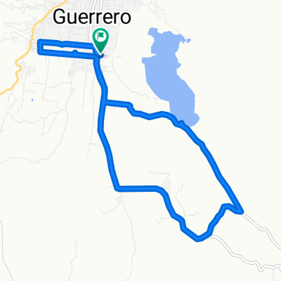
tixtla chilpancingo tixtla
A cycling route starting in Tixtla de Guerrero, Guerrero, Mexico.
Overview
About this route
Route of the race on Sunday, March 22
- -:--
- Duration
- 44.8 km
- Distance
- 884 m
- Ascent
- 884 m
- Descent
- ---
- Avg. speed
- ---
- Max. altitude

Continue with Bikemap
Use, edit, or download this cycling route
You would like to ride tixtla chilpancingo tixtla or customize it for your own trip? Here is what you can do with this Bikemap route:
Free features
- Save this route as favorite or in collections
- Copy & plan your own version of this route
- Sync your route with Garmin or Wahoo
Premium features
Free trial for 3 days, or one-time payment. More about Bikemap Premium.
- Navigate this route on iOS & Android
- Export a GPX / KML file of this route
- Create your custom printout (try it for free)
- Download this route for offline navigation
Discover more Premium features.
Get Bikemap PremiumFrom our community
Other popular routes starting in Tixtla de Guerrero
 Ruta relajada en Tixtla de Guerrero
- Distance
- 18.3 km
- Ascent
- 769 m
- Descent
- 755 m
- Location
- Tixtla de Guerrero, Guerrero, Mexico
 Ruta relajada en
- Distance
- 16.7 km
- Ascent
- 487 m
- Descent
- 352 m
- Location
- Tixtla de Guerrero, Guerrero, Mexico
 zona Arqueológica Los Tepolzin
- Distance
- 16.7 km
- Ascent
- 493 m
- Descent
- 360 m
- Location
- Tixtla de Guerrero, Guerrero, Mexico
 De Calle Igualdad 07–43, Tixtla de Guerrero a Calle Igualdad 50, Tixtla de Guerrero
- Distance
- 17.1 km
- Ascent
- 393 m
- Descent
- 393 m
- Location
- Tixtla de Guerrero, Guerrero, Mexico
 De Calle Igualdad 50, Tixtla de Guerrero a Calle Igualdad 07–43, Tixtla de Guerrero
- Distance
- 37.8 km
- Ascent
- 296 m
- Descent
- 296 m
- Location
- Tixtla de Guerrero, Guerrero, Mexico
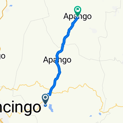 Calle Chimalpopoca, Tixtla de Guerrero a Calle Mina, Apango
- Distance
- 25 km
- Ascent
- 166 m
- Descent
- 413 m
- Location
- Tixtla de Guerrero, Guerrero, Mexico
 tixtla chilpancingo tixtla
- Distance
- 44.8 km
- Ascent
- 884 m
- Descent
- 884 m
- Location
- Tixtla de Guerrero, Guerrero, Mexico
 Calle Chimalpopoca, Tixtla de Guerrero a Calle Chimalpopoca, Tixtla de Guerrero
- Distance
- 13.1 km
- Ascent
- 124 m
- Descent
- 123 m
- Location
- Tixtla de Guerrero, Guerrero, Mexico
Open it in the app