

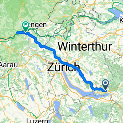
Eschenbach-Fehraltorf übers Ghöch
A cycling route starting in Eschenbach, Canton of St. Gallen, Switzerland.
Overview
About this route
In the beautiful Zürcher Oberland.
Ups and downs
- -:--
- Duration
- 42.1 km
- Distance
- 700 m
- Ascent
- 648 m
- Descent
- ---
- Avg. speed
- ---
- Max. altitude
Route quality
Waytypes & surfaces along the route
Waytypes
Road
30.7 km
(73 %)
Quiet road
3.4 km
(8 %)
Surfaces
Paved
34.9 km
(83 %)
Unpaved
0.4 km
(1 %)
Asphalt
34.9 km
(83 %)
Ground
0.4 km
(1 %)
Undefined
6.7 km
(16 %)
Continue with Bikemap
Use, edit, or download this cycling route
You would like to ride Eschenbach-Fehraltorf übers Ghöch or customize it for your own trip? Here is what you can do with this Bikemap route:
Free features
- Save this route as favorite or in collections
- Copy & plan your own version of this route
- Sync your route with Garmin or Wahoo
Premium features
Free trial for 3 days, or one-time payment. More about Bikemap Premium.
- Navigate this route on iOS & Android
- Export a GPX / KML file of this route
- Create your custom printout (try it for free)
- Download this route for offline navigation
Discover more Premium features.
Get Bikemap PremiumFrom our community
Other popular routes starting in Eschenbach
 Eschenbach - Bachtel - Atzmaennig - Eschenbach
- Distance
- 53.1 km
- Ascent
- 1,330 m
- Descent
- 1,329 m
- Location
- Eschenbach, Canton of St. Gallen, Switzerland
 VCE 2TT 2012 Eschenbach - Ischgl
- Distance
- 173.5 km
- Ascent
- 2,565 m
- Descent
- 1,680 m
- Location
- Eschenbach, Canton of St. Gallen, Switzerland
 Klöntaler See
- Distance
- 112.9 km
- Ascent
- 1,794 m
- Descent
- 1,794 m
- Location
- Eschenbach, Canton of St. Gallen, Switzerland
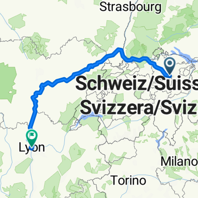 Mythenstrasse, Eschenbach SG nach Place des Terreaux, Lyon
- Distance
- 627.5 km
- Ascent
- 3,135 m
- Descent
- 3,434 m
- Location
- Eschenbach, Canton of St. Gallen, Switzerland
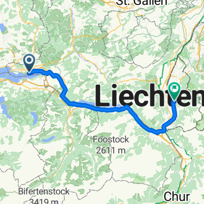 3 - Route nach Vaduz
- Distance
- 72.9 km
- Ascent
- 975 m
- Descent
- 930 m
- Location
- Eschenbach, Canton of St. Gallen, Switzerland
 High-speed route in Pfäffikon SZ
- Distance
- 39.9 km
- Ascent
- 1,592 m
- Descent
- 1,741 m
- Location
- Eschenbach, Canton of St. Gallen, Switzerland
 Eschenbach SG - Leibstadt
- Distance
- 98.6 km
- Ascent
- 799 m
- Descent
- 899 m
- Location
- Eschenbach, Canton of St. Gallen, Switzerland
 90 km Atzmaennig - Ricken - Bachmannsberg - Buechberg
- Distance
- 88.7 km
- Ascent
- 1,602 m
- Descent
- 1,602 m
- Location
- Eschenbach, Canton of St. Gallen, Switzerland
Open it in the app