

C4 A la découverte de l'Outre-Forêt
A cycling route starting in Lembach, Grand Est, France.
Overview
About this route
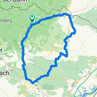
Lembach – Wissembourg – Haguenau - Lembach
The route follows the cycling path IC 20, from Lembach to Haguenau, passing through Woerth and Morsbronn-les-Bains. From Haguenau, the route leads to the Gros-Chêne, an emblematic site of the Haguenau forest, the land of potters, reaching Betschdorf via the cycling path IC 24. It then goes through the typical small villages of the Outre-Forêt and Wissembourg. It is through the cellar of Cléebourg and the Pfaffenschlick pass that one reaches Lembach.- -:--
- Duration
- 77.7 km
- Distance
- 425 m
- Ascent
- 424 m
- Descent
- ---
- Avg. speed
- ---
- Max. altitude

Route quality
Waytypes & surfaces along the route
Waytypes
Quiet road
17.1 km
(22 %)
Road
16.3 km
(21 %)
Surfaces
Paved
59.1 km
(76 %)
Unpaved
0.8 km
(1 %)
Asphalt
54.4 km
(70 %)
Paved (undefined)
4.7 km
(6 %)
Continue with Bikemap
Use, edit, or download this cycling route
You would like to ride C4 A la découverte de l'Outre-Forêt or customize it for your own trip? Here is what you can do with this Bikemap route:
Free features
- Save this route as favorite or in collections
- Copy & plan your own version of this route
- Sync your route with Garmin or Wahoo
Premium features
Free trial for 3 days, or one-time payment. More about Bikemap Premium.
- Navigate this route on iOS & Android
- Export a GPX / KML file of this route
- Create your custom printout (try it for free)
- Download this route for offline navigation
Discover more Premium features.
Get Bikemap PremiumFrom our community
Other popular routes starting in Lembach
 C3 Circuit transfrontalier
- Distance
- 45.9 km
- Ascent
- 383 m
- Descent
- 384 m
- Location
- Lembach, Grand Est, France
 C4 A la découverte de l'Outre-Forêt
- Distance
- 77.7 km
- Ascent
- 425 m
- Descent
- 424 m
- Location
- Lembach, Grand Est, France
 VTT - Marienbronn
- Distance
- 17.1 km
- Ascent
- 415 m
- Descent
- 418 m
- Location
- Lembach, Grand Est, France
 C3 Circuit transfrontalier
- Distance
- 45.9 km
- Ascent
- 382 m
- Descent
- 382 m
- Location
- Lembach, Grand Est, France
 C1 Histoire et colombages.
- Distance
- 84.3 km
- Ascent
- 618 m
- Descent
- 618 m
- Location
- Lembach, Grand Est, France
 Ex - C 01 - Entre forêt et route du vin – 42 km
- Distance
- 42.6 km
- Ascent
- 569 m
- Descent
- 569 m
- Location
- Lembach, Grand Est, France
 Biosphärenhaus
- Distance
- 37.5 km
- Ascent
- 275 m
- Descent
- 273 m
- Location
- Lembach, Grand Est, France
 Niederbronn les Bains
- Distance
- 47 km
- Ascent
- 479 m
- Descent
- 479 m
- Location
- Lembach, Grand Est, France
Open it in the app