

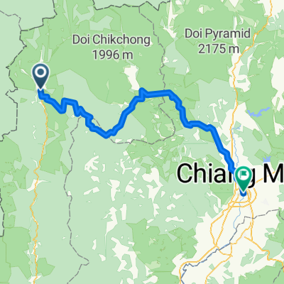
Mae H Son to Chiang M 2
A cycling route starting in Mae Hong Son, Mae Hong Son, Thailand.
Overview
About this route
south then inland past highest mountain
- -:--
- Duration
- 243.5 km
- Distance
- 3,462 m
- Ascent
- 3,393 m
- Descent
- ---
- Avg. speed
- ---
- Max. altitude
Continue with Bikemap
Use, edit, or download this cycling route
You would like to ride Mae H Son to Chiang M 2 or customize it for your own trip? Here is what you can do with this Bikemap route:
Free features
- Save this route as favorite or in collections
- Copy & plan your own version of this route
- Split it into stages to create a multi-day tour
- Sync your route with Garmin or Wahoo
Premium features
Free trial for 3 days, or one-time payment. More about Bikemap Premium.
- Navigate this route on iOS & Android
- Export a GPX / KML file of this route
- Create your custom printout (try it for free)
- Download this route for offline navigation
Discover more Premium features.
Get Bikemap PremiumFrom our community
Other popular routes starting in Mae Hong Son
 Mae Hong Son to Chiang Mai 1
- Distance
- 245.4 km
- Ascent
- 3,275 m
- Descent
- 3,202 m
- Location
- Mae Hong Son, Mae Hong Son, Thailand
 Mae Hong Son to Khun Yuam 2.0
- Distance
- 67.1 km
- Ascent
- 819 m
- Descent
- 473 m
- Location
- Mae Hong Son, Mae Hong Son, Thailand
 MH Son to Ch M 4 backroads
- Distance
- 221.2 km
- Ascent
- 3,690 m
- Descent
- 3,620 m
- Location
- Mae Hong Son, Mae Hong Son, Thailand
![Thailande 2009 [15/21]: Mae Hong Son Myanmar Border Tour](https://media.bikemap.net/routes/516379/staticmaps/in_c7965362-e4ca-4cfc-84a4-883eb6677b09_400x400_bikemap-2021-3D-static.png) Thailande 2009 [15/21]: Mae Hong Son Myanmar Border Tour
Thailande 2009 [15/21]: Mae Hong Son Myanmar Border Tour- Distance
- 24.3 km
- Ascent
- 457 m
- Descent
- 351 m
- Location
- Mae Hong Son, Mae Hong Son, Thailand
 Mae Hong Son - Khunyuam 2023
- Distance
- 68.2 km
- Ascent
- 1,488 m
- Descent
- 1,173 m
- Location
- Mae Hong Son, Mae Hong Son, Thailand
 Mae Hong Son - Mae Aw,und zurueck
- Distance
- 101.4 km
- Ascent
- 1,409 m
- Descent
- 1,377 m
- Location
- Mae Hong Son, Mae Hong Son, Thailand
 Mae H Son to Chiang M 2
- Distance
- 243.5 km
- Ascent
- 3,462 m
- Descent
- 3,393 m
- Location
- Mae Hong Son, Mae Hong Son, Thailand
 4# Mae Hong Son - Khun Yuam 70km 1200hm
- Distance
- 69.8 km
- Ascent
- 851 m
- Descent
- 558 m
- Location
- Mae Hong Son, Mae Hong Son, Thailand
Open it in the app