

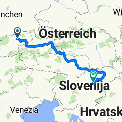
3. Etap. Inn - Donau - Tour, Wörgl - Rosenheim
A cycling route starting in Wörgl, Tyrol, Austria.
Overview
About this route
Wörgl - Angath - Oberlangkampfen - Kirchbichl - Unterlangkampfen - Endach - Kufstein - Schanz - Oberndorf - Niederndorf - Waidau - Nußdorf - Neubeuern - Pfraundorf - Thansau - Rosenheim
- -:--
- Duration
- 56.7 km
- Distance
- 19 m
- Ascent
- 107 m
- Descent
- ---
- Avg. speed
- ---
- Max. altitude

Route quality
Waytypes & surfaces along the route
Waytypes
Track
31.2 km
(55 %)
Quiet road
10.8 km
(19 %)
Surfaces
Paved
31.8 km
(56 %)
Unpaved
20.4 km
(36 %)
Asphalt
31.8 km
(56 %)
Loose gravel
13.6 km
(24 %)
Continue with Bikemap
Use, edit, or download this cycling route
You would like to ride 3. Etap. Inn - Donau - Tour, Wörgl - Rosenheim or customize it for your own trip? Here is what you can do with this Bikemap route:
Free features
- Save this route as favorite or in collections
- Copy & plan your own version of this route
- Sync your route with Garmin or Wahoo
Premium features
Free trial for 3 days, or one-time payment. More about Bikemap Premium.
- Navigate this route on iOS & Android
- Export a GPX / KML file of this route
- Create your custom printout (try it for free)
- Download this route for offline navigation
Discover more Premium features.
Get Bikemap PremiumFrom our community
Other popular routes starting in Wörgl
 Innsbrucker Straße 71, Wörgl nach Kelchsauer Straße 27, Glantersberg
- Distance
- 14.6 km
- Ascent
- 133 m
- Descent
- 6 m
- Location
- Wörgl, Tyrol, Austria
 holzalm spezial
- Distance
- 47.2 km
- Ascent
- 1,035 m
- Descent
- 1,035 m
- Location
- Wörgl, Tyrol, Austria
 2013 PMSL 008
- Distance
- 76.6 km
- Ascent
- 543 m
- Descent
- 426 m
- Location
- Wörgl, Tyrol, Austria
 Wörgl - Lofer
- Distance
- 65.3 km
- Ascent
- 1,057 m
- Descent
- 937 m
- Location
- Wörgl, Tyrol, Austria
 Von Wörgl bis Vuhred
- Distance
- 509.7 km
- Ascent
- 9,208 m
- Descent
- 9,461 m
- Location
- Wörgl, Tyrol, Austria
 Wiederhergestellte Route
- Distance
- 1 km
- Ascent
- 117 m
- Descent
- 0 m
- Location
- Wörgl, Tyrol, Austria
 Buchenweg nach Moosweg
- Distance
- 28.5 km
- Ascent
- 376 m
- Descent
- 446 m
- Location
- Wörgl, Tyrol, Austria
 von wörgl auf die hohe salve
- Distance
- 38 km
- Ascent
- 1,180 m
- Descent
- 1,166 m
- Location
- Wörgl, Tyrol, Austria
Open it in the app