

C2 Entre ville et forêt.
A cycling route starting in Lembach, Grand Est, France.
Overview
About this route
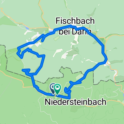
Lembach – Haguenau – Lembach
The route winds away from the departmental road to reach Reichshoffen, then Haguenau along small roads between the orchards that surround the villages. The return to Lembach, via the cycling route IC 20, passes through Walbourg, known for the stained glass windows of its church, and through Merkwiller-Pechelbronn, a historic site of the oil industry. The circuit is varied, and the sites to visit tell the industrial history of the territory.
- -:--
- Duration
- 78.6 km
- Distance
- 418 m
- Ascent
- 418 m
- Descent
- ---
- Avg. speed
- ---
- Max. altitude

Route quality
Waytypes & surfaces along the route
Waytypes
Road
36.2 km
(46 %)
Quiet road
17.3 km
(22 %)
Surfaces
Paved
44.8 km
(57 %)
Unpaved
0.8 km
(1 %)
Asphalt
40.1 km
(51 %)
Paved (undefined)
4.7 km
(6 %)
Continue with Bikemap
Use, edit, or download this cycling route
You would like to ride C2 Entre ville et forêt. or customize it for your own trip? Here is what you can do with this Bikemap route:
Free features
- Save this route as favorite or in collections
- Copy & plan your own version of this route
- Sync your route with Garmin or Wahoo
Premium features
Free trial for 3 days, or one-time payment. More about Bikemap Premium.
- Navigate this route on iOS & Android
- Export a GPX / KML file of this route
- Create your custom printout (try it for free)
- Download this route for offline navigation
Discover more Premium features.
Get Bikemap PremiumFrom our community
Other popular routes starting in Lembach
 Biosphärenhaus
- Distance
- 37.5 km
- Ascent
- 275 m
- Descent
- 273 m
- Location
- Lembach, Grand Est, France
 VTT - Marienbronn
- Distance
- 17.1 km
- Ascent
- 415 m
- Descent
- 418 m
- Location
- Lembach, Grand Est, France
 C3 Circuit transfrontalier
- Distance
- 45.9 km
- Ascent
- 382 m
- Descent
- 382 m
- Location
- Lembach, Grand Est, France
 2012 French Tour -- Ride Day 23 -- 3 September 2012 -- Climbach -- Circle
- Distance
- 48.3 km
- Ascent
- 435 m
- Descent
- 433 m
- Location
- Lembach, Grand Est, France
 Freundschafts-Tour
- Distance
- 30.4 km
- Ascent
- 706 m
- Descent
- 706 m
- Location
- Lembach, Grand Est, France
 Ex - C 01 - Entre forêt et route du vin – 42 km
- Distance
- 42.6 km
- Ascent
- 569 m
- Descent
- 569 m
- Location
- Lembach, Grand Est, France
 VTT - Le Soultzerkopf
- Distance
- 27.7 km
- Ascent
- 489 m
- Descent
- 488 m
- Location
- Lembach, Grand Est, France
 C2 Entre ville et forêt.
- Distance
- 78.6 km
- Ascent
- 418 m
- Descent
- 418 m
- Location
- Lembach, Grand Est, France
Open it in the app