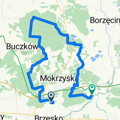
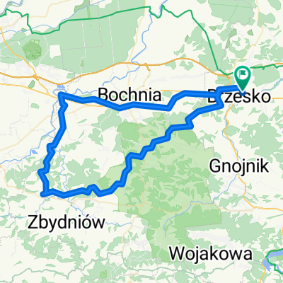
Brzesko_Rzezawa_Ujście Solne_Szczurowa_Borzęcin_Wokowice_Maszkienice_Brzesko
A cycling route starting in Brzesko, Lesser Poland Voivodeship, Poland.
Overview
About this route
21.03.2015 - 72 km
Pierwszy dzień wiosny, ok. 16 C, słonecznie.- -:--
- Duration
- 72 km
- Distance
- 83 m
- Ascent
- 87 m
- Descent
- ---
- Avg. speed
- ---
- Avg. speed
Route quality
Waytypes & surfaces along the route
Waytypes
Road
37.4 km
(52 %)
Busy road
14.6 km
(20 %)
Surfaces
Paved
45.2 km
(63 %)
Asphalt
45 km
(62 %)
Concrete
0.2 km
(<1 %)
Undefined
26.8 km
(37 %)
Continue with Bikemap
Use, edit, or download this cycling route
You would like to ride Brzesko_Rzezawa_Ujście Solne_Szczurowa_Borzęcin_Wokowice_Maszkienice_Brzesko or customize it for your own trip? Here is what you can do with this Bikemap route:
Free features
- Save this route as favorite or in collections
- Copy & plan your own version of this route
- Sync your route with Garmin or Wahoo
Premium features
Free trial for 3 days, or one-time payment. More about Bikemap Premium.
- Navigate this route on iOS & Android
- Export a GPX / KML file of this route
- Create your custom printout (try it for free)
- Download this route for offline navigation
Discover more Premium features.
Get Bikemap PremiumFrom our community
Other popular routes starting in Brzesko
- OKOCIM-N.Sącz-S.Lubovńa-S.Bela-L.Mikulas-Zuberec-Glinka-RAJCZA (14-17VIII2008)
- Distance
- 332.1 km
- Ascent
- 1,970 m
- Descent
- 1,685 m
- Location
- Brzesko, Lesser Poland Voivodeship, Poland
- R13a Brzesko - Grabie
- Distance
- 60 km
- Ascent
- 86 m
- Descent
- 113 m
- Location
- Brzesko, Lesser Poland Voivodeship, Poland
- Brzesko to Zbylitowska Góra
- Distance
- 31.6 km
- Ascent
- 654 m
- Descent
- 707 m
- Location
- Brzesko, Lesser Poland Voivodeship, Poland
- Brz-Okulice-PuszczaNiepolomicka-Bochnia-Brz
- Distance
- 53.1 km
- Ascent
- 108 m
- Descent
- 108 m
- Location
- Brzesko, Lesser Poland Voivodeship, Poland
- Gródek nad D. -> Biadoliny
- Distance
- 81.8 km
- Ascent
- 588 m
- Descent
- 592 m
- Location
- Brzesko, Lesser Poland Voivodeship, Poland
- Brzesko - Wojnicz
- Distance
- 23.5 km
- Ascent
- 391 m
- Descent
- 412 m
- Location
- Brzesko, Lesser Poland Voivodeship, Poland
- Brz-PorębaSpytk-NowyWiśnicz-Bochnia-Brz
- Distance
- 48 km
- Ascent
- 287 m
- Descent
- 287 m
- Location
- Brzesko, Lesser Poland Voivodeship, Poland
- Tadeusza Kościuszki 68, Brzesko do Tadeusza Kościuszki 72a, Brzesko
- Distance
- 8.3 km
- Ascent
- 107 m
- Descent
- 109 m
- Location
- Brzesko, Lesser Poland Voivodeship, Poland
Open it in the app