
002_WN-Schurwald-WN
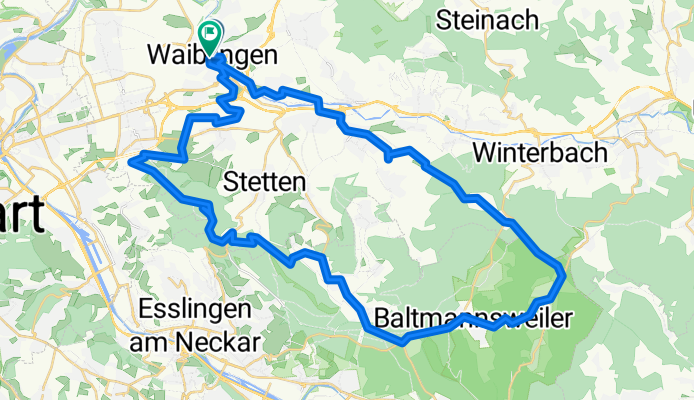
A cycling route starting in Waiblingen, Baden-Wurttemberg, Germany.
Overview
About this route
WN via Beutelsbach Hchurwald/Hohengehren Kernenturm+return
- -:--
- Duration
- 55 km
- Distance
- 674 m
- Ascent
- 665 m
- Descent
- ---
- Avg. speed
- ---
- Max. altitude

Route quality
Waytypes & surfaces along the route
Waytypes
Track
25.9 km
(47 %)
Quiet road
12.1 km
(22 %)
Surfaces
Paved
31.9 km
(58 %)
Unpaved
14.9 km
(27 %)
Asphalt
30.8 km
(56 %)
Gravel
7.7 km
(14 %)
Continue with Bikemap
Use, edit, or download this cycling route
You would like to ride 002_WN-Schurwald-WN or customize it for your own trip? Here is what you can do with this Bikemap route:
Free features
- Save this route as favorite or in collections
- Copy & plan your own version of this route
- Sync your route with Garmin or Wahoo
Premium features
Free trial for 3 days, or one-time payment. More about Bikemap Premium.
- Navigate this route on iOS & Android
- Export a GPX / KML file of this route
- Create your custom printout (try it for free)
- Download this route for offline navigation
Discover more Premium features.
Get Bikemap PremiumFrom our community
Other popular routes starting in Waiblingen
 Rems und Neckar
- Distance
- 52.1 km
- Ascent
- 181 m
- Descent
- 196 m
- Location
- Waiblingen, Baden-Wurttemberg, Germany
 Waiblingen über Kappelberg (Kernenturm)nach Waiblingen
- Distance
- 35.5 km
- Ascent
- 427 m
- Descent
- 430 m
- Location
- Waiblingen, Baden-Wurttemberg, Germany
 Waiblingen über Schmiden am Besinnungsweg entlang bis zum Mount Oeffingen und zum Max-Eyth -See
- Distance
- 21.6 km
- Ascent
- 72 m
- Descent
- 185 m
- Location
- Waiblingen, Baden-Wurttemberg, Germany
 Runde um den Schurwald
- Distance
- 41.4 km
- Ascent
- 489 m
- Descent
- 534 m
- Location
- Waiblingen, Baden-Wurttemberg, Germany
 Durch den Buocher Wald
- Distance
- 48.9 km
- Ascent
- 492 m
- Descent
- 492 m
- Location
- Waiblingen, Baden-Wurttemberg, Germany
 WN: Langer Kurs über Bittenfeld - Winnenden - Bouch
- Distance
- 43.2 km
- Ascent
- 479 m
- Descent
- 479 m
- Location
- Waiblingen, Baden-Wurttemberg, Germany
 002_WN-Schurwald-WN
- Distance
- 55 km
- Ascent
- 674 m
- Descent
- 665 m
- Location
- Waiblingen, Baden-Wurttemberg, Germany
 Runde Welzheim 100 km
- Distance
- 93.2 km
- Ascent
- 677 m
- Descent
- 674 m
- Location
- Waiblingen, Baden-Wurttemberg, Germany
Open it in the app