

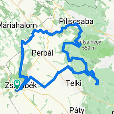
Zsámbék-Dobogókő-Zsámbék
A cycling route starting in Zsámbék, Pest County, Hungary.
Overview
About this route
. (cloned from route 2938936)
(cloned from route 2938979)
- -:--
- Duration
- 95.8 km
- Distance
- 1,061 m
- Ascent
- 1,060 m
- Descent
- ---
- Avg. speed
- ---
- Max. altitude

Route quality
Waytypes & surfaces along the route
Waytypes
Quiet road
17.2 km
(18 %)
Road
13.4 km
(14 %)
Surfaces
Paved
62.3 km
(65 %)
Unpaved
1 km
(1 %)
Asphalt
61.3 km
(64 %)
Paved (undefined)
1 km
(1 %)
Continue with Bikemap
Use, edit, or download this cycling route
You would like to ride Zsámbék-Dobogókő-Zsámbék or customize it for your own trip? Here is what you can do with this Bikemap route:
Free features
- Save this route as favorite or in collections
- Copy & plan your own version of this route
- Split it into stages to create a multi-day tour
- Sync your route with Garmin or Wahoo
Premium features
Free trial for 3 days, or one-time payment. More about Bikemap Premium.
- Navigate this route on iOS & Android
- Export a GPX / KML file of this route
- Create your custom printout (try it for free)
- Download this route for offline navigation
Discover more Premium features.
Get Bikemap PremiumFrom our community
Other popular routes starting in Zsámbék
 Petőfi Sándor utca, Zsámbék - Petőfi Sándor utca, Zsámbék
- Distance
- 12.8 km
- Ascent
- 110 m
- Descent
- 109 m
- Location
- Zsámbék, Pest County, Hungary
 Honvéd utca, Zsámbék - Petőfi Sándor utca, Zsámbék
- Distance
- 10 km
- Ascent
- 48 m
- Descent
- 48 m
- Location
- Zsámbék, Pest County, Hungary
 2013.09.02.
- Distance
- 57.2 km
- Ascent
- 737 m
- Descent
- 737 m
- Location
- Zsámbék, Pest County, Hungary
 Rövidkör
- Distance
- 34.5 km
- Ascent
- 336 m
- Descent
- 390 m
- Location
- Zsámbék, Pest County, Hungary
 Otthon-Etyek BUBA
- Distance
- 22.7 km
- Ascent
- 144 m
- Descent
- 156 m
- Location
- Zsámbék, Pest County, Hungary
 Zsámbék - Tök
- Distance
- 17.8 km
- Ascent
- 114 m
- Descent
- 155 m
- Location
- Zsámbék, Pest County, Hungary
 Széchenyi István utca, Tök - Bakony utca, Balatonakarattya
- Distance
- 111.5 km
- Ascent
- 855 m
- Descent
- 847 m
- Location
- Zsámbék, Pest County, Hungary
 Hegyalja út - Hegyalja út
- Distance
- 15.4 km
- Ascent
- 82 m
- Descent
- 131 m
- Location
- Zsámbék, Pest County, Hungary
Open it in the app