

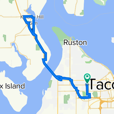
UP/Tacoma waterfront ride....medium effort
A cycling route starting in Fircrest, Washington, United States.
Overview
About this route
A nice 28 mile ride through UP/Tacoma waterfront areas. 1800 feet vertical ascent, but its pretty spreadout. There are however some awesome downhills, 40mph on a road bike. mtb hit 48mph - N30th, last mile of 5 mile drive, 6th Ave, several smaller hills in the waterfront area of UP. End with a quick 200 foot climb over a block to end.
This route keeps you pretty well out of traffic, at least the main arterials, except N 30th and Ruston. Make sure you have lights on your boike for the 51st street tunnel. (cloned from route 338636)- -:--
- Duration
- 44.9 km
- Distance
- 502 m
- Ascent
- 502 m
- Descent
- ---
- Avg. speed
- ---
- Max. altitude
Continue with Bikemap
Use, edit, or download this cycling route
You would like to ride UP/Tacoma waterfront ride....medium effort or customize it for your own trip? Here is what you can do with this Bikemap route:
Free features
- Save this route as favorite or in collections
- Copy & plan your own version of this route
- Sync your route with Garmin or Wahoo
Premium features
Free trial for 3 days, or one-time payment. More about Bikemap Premium.
- Navigate this route on iOS & Android
- Export a GPX / KML file of this route
- Create your custom printout (try it for free)
- Download this route for offline navigation
Discover more Premium features.
Get Bikemap PremiumFrom our community
Other popular routes starting in Fircrest
 UP/Tacoma waterfront ride....medium effort
- Distance
- 44.9 km
- Ascent
- 502 m
- Descent
- 502 m
- Location
- Fircrest, Washington, United States
 Narrow Bridge to Fox Island Bridge
- Distance
- 16 km
- Ascent
- 200 m
- Descent
- 298 m
- Location
- Fircrest, Washington, United States
 Pretty good Tacoma-Seattle route
- Distance
- 13.3 km
- Ascent
- 15 m
- Descent
- 126 m
- Location
- Fircrest, Washington, United States
 HHH MLK Ride
- Distance
- 40.5 km
- Ascent
- 497 m
- Descent
- 497 m
- Location
- Fircrest, Washington, United States
 work to debs
- Distance
- 7.1 km
- Ascent
- 116 m
- Descent
- 74 m
- Location
- Fircrest, Washington, United States
 Central Tacoma - Gig Harbor
- Distance
- 38.1 km
- Ascent
- 546 m
- Descent
- 548 m
- Location
- Fircrest, Washington, United States
 Home to YMCA
- Distance
- 9.5 km
- Ascent
- 81 m
- Descent
- 117 m
- Location
- Fircrest, Washington, United States
 UP/Tacoma waterfront ride....medium effort
- Distance
- 44.9 km
- Ascent
- 483 m
- Descent
- 488 m
- Location
- Fircrest, Washington, United States
Open it in the app