

Elisabethenwört_1
A cycling route starting in Linkenheim-Hochstetten, Baden-Wurttemberg, Germany.
Overview
About this route
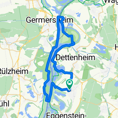
Route from Dettenheim to Elisabethenwört Island.
Elisabethenwört Island is a nature reserve near the Rhine.
- -:--
- Duration
- 8.3 km
- Distance
- 39 m
- Ascent
- 39 m
- Descent
- ---
- Avg. speed
- ---
- Max. altitude
Route quality
Waytypes & surfaces along the route
Waytypes
Track
5.5 km
(66 %)
Quiet road
2.2 km
(26 %)
Surfaces
Paved
4.1 km
(49 %)
Unpaved
4 km
(48 %)
Asphalt
4.1 km
(49 %)
Gravel
2.7 km
(32 %)
Route highlights
Points of interest along the route
Point of interest after 3.9 km
Hinweisschild Insel Elisabethenwört
Continue with Bikemap
Use, edit, or download this cycling route
You would like to ride Elisabethenwört_1 or customize it for your own trip? Here is what you can do with this Bikemap route:
Free features
- Save this route as favorite or in collections
- Copy & plan your own version of this route
- Sync your route with Garmin or Wahoo
Premium features
Free trial for 3 days, or one-time payment. More about Bikemap Premium.
- Navigate this route on iOS & Android
- Export a GPX / KML file of this route
- Create your custom printout (try it for free)
- Download this route for offline navigation
Discover more Premium features.
Get Bikemap PremiumFrom our community
Other popular routes starting in Linkenheim-Hochstetten
 An der Bahn 17, Linkenheim-Hochstetten nach An der Bahn 17, Linkenheim-Hochstetten
- Distance
- 24.3 km
- Ascent
- 22 m
- Descent
- 71 m
- Location
- Linkenheim-Hochstetten, Baden-Wurttemberg, Germany
 Elisabethenwört_1
- Distance
- 8.3 km
- Ascent
- 39 m
- Descent
- 39 m
- Location
- Linkenheim-Hochstetten, Baden-Wurttemberg, Germany
 43 K Trainingsheimfahrt flach
- Distance
- 43.1 km
- Ascent
- 48 m
- Descent
- 51 m
- Location
- Linkenheim-Hochstetten, Baden-Wurttemberg, Germany
 Ungeheuerklamm-Trail
- Distance
- 45.7 km
- Ascent
- 383 m
- Descent
- 382 m
- Location
- Linkenheim-Hochstetten, Baden-Wurttemberg, Germany
 Linkenheim-Leo-Pfinzentlastungskanäle-BaLi-Linkenheim
- Distance
- 20.6 km
- Ascent
- 54 m
- Descent
- 56 m
- Location
- Linkenheim-Hochstetten, Baden-Wurttemberg, Germany
 Ins Kraichgauer Hügelland 2021 - 74 km Permanente des RV Badenia Linkenheim 1900 e.V.
- Distance
- 71.4 km
- Ascent
- 261 m
- Descent
- 260 m
- Location
- Linkenheim-Hochstetten, Baden-Wurttemberg, Germany
 route66
- Distance
- 37.4 km
- Ascent
- 50 m
- Descent
- 49 m
- Location
- Linkenheim-Hochstetten, Baden-Wurttemberg, Germany
 Vom Rhein an den Schwarzwald - RTF des RV Badenia Linkenheim 1900 e.V. - 77 km Strecke
- Distance
- 76.1 km
- Ascent
- 396 m
- Descent
- 396 m
- Location
- Linkenheim-Hochstetten, Baden-Wurttemberg, Germany
Open it in the app