

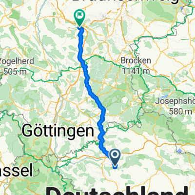
Bahntrasse Braunlage Walkenried
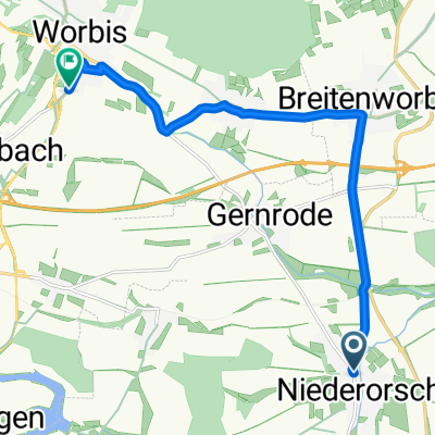
A cycling route starting in Niederorschel, Thuringia, Germany.
Overview
About this route
TEASI track
- -:--
- Duration
- 64.6 km
- Distance
- 1,006 m
- Ascent
- 323 m
- Descent
- ---
- Avg. speed
- ---
- Max. altitude

Route quality
Waytypes & surfaces along the route
Waytypes
Track
20 km
(31 %)
Quiet road
7.8 km
(12 %)
Surfaces
Paved
34.3 km
(53 %)
Unpaved
19.4 km
(30 %)
Asphalt
33.6 km
(52 %)
Unpaved (undefined)
11 km
(17 %)
Continue with Bikemap
Use, edit, or download this cycling route
You would like to ride Bahntrasse Braunlage Walkenried or customize it for your own trip? Here is what you can do with this Bikemap route:
Free features
- Save this route as favorite or in collections
- Copy & plan your own version of this route
- Sync your route with Garmin or Wahoo
Premium features
Free trial for 3 days, or one-time payment. More about Bikemap Premium.
- Navigate this route on iOS & Android
- Export a GPX / KML file of this route
- Create your custom printout (try it for free)
- Download this route for offline navigation
Discover more Premium features.
Get Bikemap PremiumFrom our community
Other popular routes starting in Niederorschel
 Neue Mühle Niederorschel nach Heiligenstadt
- Distance
- 63 km
- Ascent
- 1,619 m
- Descent
- 1,621 m
- Location
- Niederorschel, Thuringia, Germany
 Marktplatz 15, Niederorschel nach Hauptstraße 61, Niederorschel
- Distance
- 0.5 km
- Ascent
- 0 m
- Descent
- 0 m
- Location
- Niederorschel, Thuringia, Germany
 Hauptstraße 9, Niederorschel nach Hauptstraße 10, Niederorschel
- Distance
- 19.6 km
- Ascent
- 180 m
- Descent
- 189 m
- Location
- Niederorschel, Thuringia, Germany
 Rautenstraße 57–60, Niederorschel nach Bruch 8, Niederorschel
- Distance
- 5.4 km
- Ascent
- 22 m
- Descent
- 87 m
- Location
- Niederorschel, Thuringia, Germany
 Niederorschel - Brocken - Niederorschel
- Distance
- 152 km
- Ascent
- 850 m
- Descent
- 517 m
- Location
- Niederorschel, Thuringia, Germany
 Hauptstraße nach Industriestraße
- Distance
- 10.5 km
- Ascent
- 97 m
- Descent
- 49 m
- Location
- Niederorschel, Thuringia, Germany
 Bahnhofstraße 83, Niederorschel nach B247, Hattorf am Harz
- Distance
- 38.1 km
- Ascent
- 157 m
- Descent
- 278 m
- Location
- Niederorschel, Thuringia, Germany
 Niederorschel - Holle
- Distance
- 107.2 km
- Ascent
- 769 m
- Descent
- 1,065 m
- Location
- Niederorschel, Thuringia, Germany
Open it in the app