

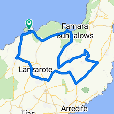
Lanzarote Giorno 2
A cycling route starting in Tinajo, Canary Islands, Spain.
Overview
About this route
Lanzarote Day 2
- -:--
- Duration
- 114.6 km
- Distance
- 1,445 m
- Ascent
- 1,449 m
- Descent
- ---
- Avg. speed
- ---
- Max. altitude

Route quality
Waytypes & surfaces along the route
Waytypes
Track
12.6 km
(11 %)
Road
10.3 km
(9 %)
Surfaces
Paved
88.2 km
(77 %)
Unpaved
12.6 km
(11 %)
Asphalt
88.2 km
(77 %)
Gravel
4.6 km
(4 %)
Continue with Bikemap
Use, edit, or download this cycling route
You would like to ride Lanzarote Giorno 2 or customize it for your own trip? Here is what you can do with this Bikemap route:
Free features
- Save this route as favorite or in collections
- Copy & plan your own version of this route
- Split it into stages to create a multi-day tour
- Sync your route with Garmin or Wahoo
Premium features
Free trial for 3 days, or one-time payment. More about Bikemap Premium.
- Navigate this route on iOS & Android
- Export a GPX / KML file of this route
- Create your custom printout (try it for free)
- Download this route for offline navigation
Discover more Premium features.
Get Bikemap PremiumFrom our community
Other popular routes starting in Tinajo
 Nationalpark Timanfaya (Feuerberge)
- Distance
- 56 km
- Ascent
- 594 m
- Descent
- 597 m
- Location
- Tinajo, Canary Islands, Spain
 La Santa-TiAqua-Tinajo-LaSanta
- Distance
- 21.1 km
- Ascent
- 222 m
- Descent
- 223 m
- Location
- Tinajo, Canary Islands, Spain
 Kanári szigetek 4. nap
- Distance
- 90.4 km
- Ascent
- 706 m
- Descent
- 626 m
- Location
- Tinajo, Canary Islands, Spain
 Conil Trip - Distance 50km
- Distance
- 52.2 km
- Ascent
- 415 m
- Descent
- 415 m
- Location
- Tinajo, Canary Islands, Spain
 Lanzarote Playa Blanca
- Distance
- 88.3 km
- Ascent
- 883 m
- Descent
- 890 m
- Location
- Tinajo, Canary Islands, Spain
 Feuer lang 59
- Distance
- 59.7 km
- Ascent
- 879 m
- Descent
- 880 m
- Location
- Tinajo, Canary Islands, Spain
 La Santa El Mojon Tahiche
- Distance
- 66.6 km
- Ascent
- 679 m
- Descent
- 680 m
- Location
- Tinajo, Canary Islands, Spain
 65km Inseltour Vegueta
- Distance
- 65.3 km
- Ascent
- 825 m
- Descent
- 825 m
- Location
- Tinajo, Canary Islands, Spain
Open it in the app