
kijken of het lukt
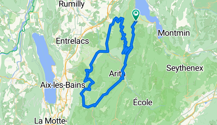
A cycling route starting in Saint-Jorioz, Auvergne-Rhône-Alpes, France.
Overview
About this route
2013 TDF section
(cloned from route 2076259)
- -:--
- Duration
- 100.5 km
- Distance
- 2,359 m
- Ascent
- 2,355 m
- Descent
- ---
- Avg. speed
- ---
- Max. altitude

Route quality
Waytypes & surfaces along the route
Waytypes
Road
17.1 km
(17 %)
Quiet road
7 km
(7 %)
Surfaces
Paved
85.4 km
(85 %)
Unpaved
1 km
(1 %)
Asphalt
85.4 km
(85 %)
Gravel
1 km
(1 %)
Undefined
14.1 km
(14 %)
Continue with Bikemap
Use, edit, or download this cycling route
You would like to ride kijken of het lukt or customize it for your own trip? Here is what you can do with this Bikemap route:
Free features
- Save this route as favorite or in collections
- Copy & plan your own version of this route
- Split it into stages to create a multi-day tour
- Sync your route with Garmin or Wahoo
Premium features
Free trial for 3 days, or one-time payment. More about Bikemap Premium.
- Navigate this route on iOS & Android
- Export a GPX / KML file of this route
- Create your custom printout (try it for free)
- Download this route for offline navigation
Discover more Premium features.
Get Bikemap PremiumFrom our community
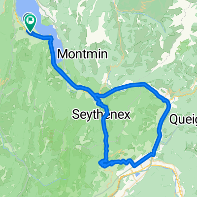
Other popular routes starting in Saint-Jorioz
 kijken of het lukt
- Distance
- 100.5 km
- Ascent
- 2,359 m
- Descent
- 2,355 m
- Location
- Saint-Jorioz, Auvergne-Rhône-Alpes, France
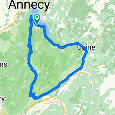 boucle leschaux frene albertville
- Distance
- 109.6 km
- Ascent
- 1,772 m
- Descent
- 1,774 m
- Location
- Saint-Jorioz, Auvergne-Rhône-Alpes, France
 Route du Laudon, Saint-Jorioz to Le Solitaire du Lac, Saint-Jorioz
- Distance
- 38.2 km
- Ascent
- 201 m
- Descent
- 208 m
- Location
- Saint-Jorioz, Auvergne-Rhône-Alpes, France
 kijken of het lukt 2
- Distance
- 85.7 km
- Ascent
- 1,836 m
- Descent
- 1,829 m
- Location
- Saint-Jorioz, Auvergne-Rhône-Alpes, France
 Maison de Pins-Mont Revard-Quintal-Semnoz-return
- Distance
- 100.5 km
- Ascent
- 2,359 m
- Descent
- 2,355 m
- Location
- Saint-Jorioz, Auvergne-Rhône-Alpes, France
 boucle tamie albertville
- Distance
- 74.7 km
- Ascent
- 872 m
- Descent
- 874 m
- Location
- Saint-Jorioz, Auvergne-Rhône-Alpes, France
 ALPSMAX XTREME TRIATHLON
- Distance
- 181.7 km
- Ascent
- 3,456 m
- Descent
- 3,456 m
- Location
- Saint-Jorioz, Auvergne-Rhône-Alpes, France
 Route de Sales, Saint-Jorioz nach Route de Sales, Saint-Jorioz
- Distance
- 39.7 km
- Ascent
- 572 m
- Descent
- 575 m
- Location
- Saint-Jorioz, Auvergne-Rhône-Alpes, France
Open it in the app