Kogelrunde
A cycling route starting in Feldbach, Styria, Austria.
Overview
About this route
Surveyed the forest educational trails at Gleichenberger Kogel.
Please be considerate of hikers and walkers!! (cloned from route 1931319)- -:--
- Duration
- 29.6 km
- Distance
- 724 m
- Ascent
- 723 m
- Descent
- ---
- Avg. speed
- ---
- Max. altitude
Continue with Bikemap
Use, edit, or download this cycling route
You would like to ride Kogelrunde or customize it for your own trip? Here is what you can do with this Bikemap route:
Free features
- Save this route as favorite or in collections
- Copy & plan your own version of this route
- Sync your route with Garmin or Wahoo
Premium features
Free trial for 3 days, or one-time payment. More about Bikemap Premium.
- Navigate this route on iOS & Android
- Export a GPX / KML file of this route
- Create your custom printout (try it for free)
- Download this route for offline navigation
Discover more Premium features.
Get Bikemap PremiumFrom our community
Other popular routes starting in Feldbach
- Weinweg der Sinne
- Distance
- 43.8 km
- Ascent
- 669 m
- Descent
- 671 m
- Location
- Feldbach, Styria, Austria
- 230313 15:01:02
- Distance
- 44.6 km
- Ascent
- 852 m
- Descent
- 849 m
- Location
- Feldbach, Styria, Austria
- 210429 13:54:08
- Distance
- 41.6 km
- Ascent
- 959 m
- Descent
- 960 m
- Location
- Feldbach, Styria, Austria
- FB-Jennersdorf-FF-Ilz
- Distance
- 69.2 km
- Ascent
- 402 m
- Descent
- 402 m
- Location
- Feldbach, Styria, Austria
- Kogelrunde
- Distance
- 29.6 km
- Ascent
- 724 m
- Descent
- 723 m
- Location
- Feldbach, Styria, Austria
- Kalvarienberg/Feldbach-Gleichenberger Kogel-Steinberg
- Distance
- 44.8 km
- Ascent
- 1,396 m
- Descent
- 1,393 m
- Location
- Feldbach, Styria, Austria
- Hochstradenrunde
- Distance
- 44.1 km
- Ascent
- 953 m
- Descent
- 953 m
- Location
- Feldbach, Styria, Austria
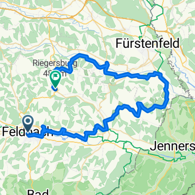
- Buschenschank Monschein
- Distance
- 46.9 km
- Ascent
- 604 m
- Descent
- 604 m
- Location
- Feldbach, Styria, Austria
Open it in the app