

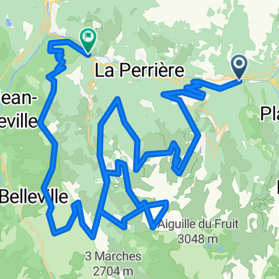
Vanoise #1
A cycling route starting in Bozel, Auvergne-Rhône-Alpes, France.
Overview
About this route
Villemartin, Champagny, Pralognan, Les Prioux. Out and back
- -:--
- Duration
- 50 km
- Distance
- 1,394 m
- Ascent
- 1,392 m
- Descent
- ---
- Avg. speed
- ---
- Max. altitude
Route quality
Waytypes & surfaces along the route
Waytypes
Road
21.5 km
(43 %)
Quiet road
6 km
(12 %)
Undefined
22.5 km
(45 %)
Surfaces
Paved
12.5 km
(25 %)
Asphalt
12.5 km
(25 %)
Undefined
37.5 km
(75 %)
Continue with Bikemap
Use, edit, or download this cycling route
You would like to ride Vanoise #1 or customize it for your own trip? Here is what you can do with this Bikemap route:
Free features
- Save this route as favorite or in collections
- Copy & plan your own version of this route
- Sync your route with Garmin or Wahoo
Premium features
Free trial for 3 days, or one-time payment. More about Bikemap Premium.
- Navigate this route on iOS & Android
- Export a GPX / KML file of this route
- Create your custom printout (try it for free)
- Download this route for offline navigation
Discover more Premium features.
Get Bikemap PremiumFrom our community
Other popular routes starting in Bozel
 Vanoise #1
- Distance
- 50 km
- Ascent
- 1,394 m
- Descent
- 1,392 m
- Location
- Bozel, Auvergne-Rhône-Alpes, France
 d5 bozel - brides les bains
- Distance
- 77.5 km
- Ascent
- 3,858 m
- Descent
- 4,076 m
- Location
- Bozel, Auvergne-Rhône-Alpes, France
 Val t and back
- Distance
- 101.8 km
- Ascent
- 2,500 m
- Descent
- 2,492 m
- Location
- Bozel, Auvergne-Rhône-Alpes, France
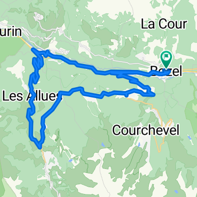 Bozel Bides Les Bains Meribel Les Allues Courchevel Le Praz Bozel
- Distance
- 35.1 km
- Ascent
- 971 m
- Descent
- 971 m
- Location
- Bozel, Auvergne-Rhône-Alpes, France
 Alp race
- Distance
- 123.4 km
- Ascent
- 7,313 m
- Descent
- 6,214 m
- Location
- Bozel, Auvergne-Rhône-Alpes, France
 Rue Jean Jaurès 227, Bozel to Route Impériale 2, Marthod
- Distance
- 81.2 km
- Ascent
- 435 m
- Descent
- 915 m
- Location
- Bozel, Auvergne-Rhône-Alpes, France
 Moutiers
- Distance
- 33.7 km
- Ascent
- 1,762 m
- Descent
- 1,759 m
- Location
- Bozel, Auvergne-Rhône-Alpes, France
 Roc du Becoin
- Distance
- 32.5 km
- Ascent
- 1,845 m
- Descent
- 1,835 m
- Location
- Bozel, Auvergne-Rhône-Alpes, France
Open it in the app