

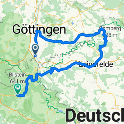
Groß Schneen 34,5km MTB--Tour
A cycling route starting in Gemeinde Friedland, Lower Saxony, Germany.
Overview
About this route
800 HM und ein paar Trails
(cloned from route 2283441) <iframe class="igtranslator-iframe" frameborder="0" scrolling="no" src="about:blank"></iframe><div class="igtranslator-activator-icon" style="background-image: url(resource://jid1-dgnibwqga0sibw-at-jetpack/igtranslator/data/content_script/icon.png)" title="Click to Show Translation"> </div>
- -:--
- Duration
- 35.1 km
- Distance
- 646 m
- Ascent
- 646 m
- Descent
- ---
- Avg. speed
- ---
- Max. altitude

Route quality
Waytypes & surfaces along the route
Waytypes
Track
23.7 km
(68 %)
Road
3.7 km
(10 %)
Surfaces
Paved
10.3 km
(29 %)
Unpaved
22.5 km
(64 %)
Ground
9.2 km
(26 %)
Gravel
9 km
(26 %)
Continue with Bikemap
Use, edit, or download this cycling route
You would like to ride Groß Schneen 34,5km MTB--Tour or customize it for your own trip? Here is what you can do with this Bikemap route:
Free features
- Save this route as favorite or in collections
- Copy & plan your own version of this route
- Sync your route with Garmin or Wahoo
Premium features
Free trial for 3 days, or one-time payment. More about Bikemap Premium.
- Navigate this route on iOS & Android
- Export a GPX / KML file of this route
- Create your custom printout (try it for free)
- Download this route for offline navigation
Discover more Premium features.
Get Bikemap PremiumFrom our community
Other popular routes starting in Gemeinde Friedland
 Groß Schneen - Billingshausen
- Distance
- 31.4 km
- Ascent
- 413 m
- Descent
- 390 m
- Location
- Gemeinde Friedland, Lower Saxony, Germany
 Eichsfeld-Werratal-Hainich-Unstrut-Runde
- Distance
- 134.6 km
- Ascent
- 1,060 m
- Descent
- 1,060 m
- Location
- Gemeinde Friedland, Lower Saxony, Germany
 Solling-Tour- Bad Karlshafeb
- Distance
- 148.2 km
- Ascent
- 1,052 m
- Descent
- 1,052 m
- Location
- Gemeinde Friedland, Lower Saxony, Germany
 Melli_1
- Distance
- 139.2 km
- Ascent
- 1,558 m
- Descent
- 1,350 m
- Location
- Gemeinde Friedland, Lower Saxony, Germany
 Friedland - NOM Hafen
- Distance
- 82.1 km
- Ascent
- 138 m
- Descent
- 137 m
- Location
- Gemeinde Friedland, Lower Saxony, Germany
 Melli25_T1
- Distance
- 48.1 km
- Ascent
- 292 m
- Descent
- 286 m
- Location
- Gemeinde Friedland, Lower Saxony, Germany
 Burg Hanstein-Schloß Berlepsch 44,6 km
- Distance
- 44.7 km
- Ascent
- 676 m
- Descent
- 676 m
- Location
- Gemeinde Friedland, Lower Saxony, Germany
 Werra-Weser-Gauß-Tour
- Distance
- 115 km
- Ascent
- 1,004 m
- Descent
- 1,004 m
- Location
- Gemeinde Friedland, Lower Saxony, Germany
Open it in the app