

Jux (Berg & Höhle)
A cycling route starting in Rudersberg, Baden-Wurttemberg, Germany.
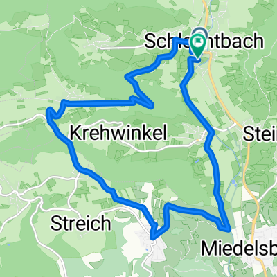
Overview
About this route
Die Höhle ist nicht begehbar.
- -:--
- Duration
- 7.6 km
- Distance
- 268 m
- Ascent
- 268 m
- Descent
- ---
- Avg. speed
- ---
- Max. altitude
Continue with Bikemap
Use, edit, or download this cycling route
You would like to ride Jux (Berg & Höhle) or customize it for your own trip? Here is what you can do with this Bikemap route:
Free features
- Save this route as favorite or in collections
- Copy & plan your own version of this route
- Sync your route with Garmin or Wahoo
Premium features
Free trial for 3 days, or one-time payment. More about Bikemap Premium.
- Navigate this route on iOS & Android
- Export a GPX / KML file of this route
- Create your custom printout (try it for free)
- Download this route for offline navigation
Discover more Premium features.
Get Bikemap PremiumFrom our community
Other popular routes starting in Rudersberg
 3/4 Stunde
- Distance
- 12.5 km
- Ascent
- 265 m
- Descent
- 266 m
- Location
- Rudersberg, Baden-Wurttemberg, Germany
 Berglen-WelzheimerWald-kurz850hm
- Distance
- 46.4 km
- Ascent
- 764 m
- Descent
- 761 m
- Location
- Rudersberg, Baden-Wurttemberg, Germany
 Berg und Wieslauftaltour
- Distance
- 42.7 km
- Ascent
- 446 m
- Descent
- 443 m
- Location
- Rudersberg, Baden-Wurttemberg, Germany
 Rudersberg über Hohen Staufen
- Distance
- 82.7 km
- Ascent
- 1,360 m
- Descent
- 1,276 m
- Location
- Rudersberg, Baden-Wurttemberg, Germany
 Lutzenberg Ebnisee Edelmannshof Klaffenbach
- Distance
- 29.9 km
- Ascent
- 464 m
- Descent
- 605 m
- Location
- Rudersberg, Baden-Wurttemberg, Germany
 Herrliche Wanderung mit schönen Ausblicken auf guten Wegen
- Distance
- 14.1 km
- Ascent
- 391 m
- Descent
- 390 m
- Location
- Rudersberg, Baden-Wurttemberg, Germany
 HighSun
- Distance
- 20.4 km
- Ascent
- 544 m
- Descent
- 462 m
- Location
- Rudersberg, Baden-Wurttemberg, Germany
 Wieslauftal - Ebnisee - Kesselgrotte - Waldenstein
- Distance
- 27.2 km
- Ascent
- 405 m
- Descent
- 405 m
- Location
- Rudersberg, Baden-Wurttemberg, Germany
Open it in the app