- 77.2 km
- 1,513 m
- 1,455 m
- Garmisch-Partenkirchen, Bavaria, Germany
Von Garmisch zum Schachen
A cycling route starting in Garmisch-Partenkirchen, Bavaria, Germany.
Overview
About this route
Beautiful tour along the Partnach and from Schachen an amazing view into the Reintal valley.
Right after starting at the Olympic Stadium, it begins quite steeply with over 20%, then after Partnachalm it gets more comfortable. Shortly before Ferchensee on the Bannholzweg, it goes uphill all the way to Schachen. The last few meters drag out, always keeping the Schachen house in sight. The descent is on the same path down to Wettersteinalpe, at the fork go straight towards Elmau following the forest highway. On the way back to the stadium, either take the easier route via Vorder- Hintergraseck or via Wamberg. Shortly before and after Wamberg, there is an extremely steep descent (30%) requiring full concentration.
- -:--
- Duration
- 44.7 km
- Distance
- 1,559 m
- Ascent
- 1,556 m
- Descent
- ---
- Avg. speed
- ---
- Max. altitude
created this 10 years ago
Continue with Bikemap
Use, edit, or download this cycling route
You would like to ride Von Garmisch zum Schachen or customize it for your own trip? Here is what you can do with this Bikemap route:
Free features
- Save this route as favorite or in collections
- Copy & plan your own version of this route
- Sync your route with Garmin or Wahoo
Premium features
Free trial for 3 days, or one-time payment. More about Bikemap Premium.
- Navigate this route on iOS & Android
- Export a GPX / KML file of this route
- Create your custom printout (try it for free)
- Download this route for offline navigation
Discover more Premium features.
Get Bikemap PremiumFrom our community
Other popular routes starting in Garmisch-Partenkirchen
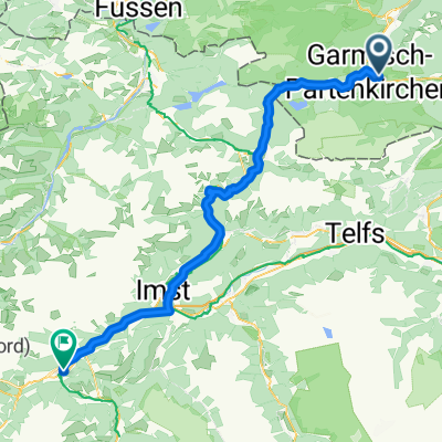
- Garmisch-Partenkirchen - tarrenz
- Am Eisstadion nach Am Ferchensee
- 31.8 km
- 759 m
- 403 m
- Garmisch-Partenkirchen, Bavaria, Germany
- Alta Via Claudia ab Garmisch
- 455.5 km
- 9,724 m
- 10,360 m
- Garmisch-Partenkirchen, Bavaria, Germany
- Partenkirchen - okolo Wangu
- 23.6 km
- 842 m
- 842 m
- Garmisch-Partenkirchen, Bavaria, Germany
- z-B07GAP-Garmisch Skistadion-Klais-Mittenwald-Lautersee-Ferchensee-Elmau-Eckbauer Bahn
- 32.2 km
- 811 m
- 815 m
- Garmisch-Partenkirchen, Bavaria, Germany
- Radtour durch das Loisachtal
- 48.3 km
- 155 m
- 156 m
- Garmisch-Partenkirchen, Bavaria, Germany
- 7POIwithImage
- 16.7 km
- 1,072 m
- 1,072 m
- Garmisch-Partenkirchen, Bavaria, Germany
- von Garmisch-Partenkirchen nach Tegernsee
- 434.2 km
- 9,136 m
- 9,110 m
- Garmisch-Partenkirchen, Bavaria, Germany
Open it in the app


