

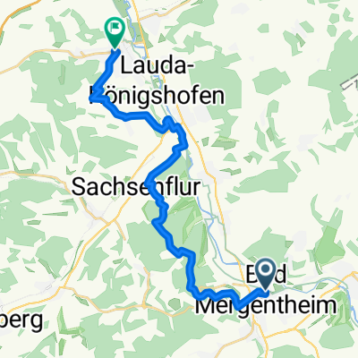
Streuobstwiesen-Tour
A cycling route starting in Bad Mergentheim, Baden-Wurttemberg, Germany.
Overview
About this route
This route follows farm roads and lightly trafficked streets along many scattered orchards. The tour is especially beautiful in spring, during the fruit tree blossom, and in autumn, when the trees bear fruit. Between Wachbach and Bad Mergentheim, the orchard education trail is used, where traditional fruit tree varieties grow that have become forgotten in many places.
- -:--
- Duration
- 34 km
- Distance
- 275 m
- Ascent
- 272 m
- Descent
- ---
- Avg. speed
- ---
- Max. altitude

Route quality
Waytypes & surfaces along the route
Waytypes
Quiet road
15.6 km
(46 %)
Road
8.8 km
(26 %)
Surfaces
Paved
26.8 km
(79 %)
Unpaved
1.4 km
(4 %)
Asphalt
22.1 km
(65 %)
Paved (undefined)
4.8 km
(14 %)
Route highlights
Points of interest along the route
Point of interest after 18 km
Ein Bad im Hollenbaucher Stausee kann nach dem Anstieg erfrischen.
Point of interest after 29.3 km
Obstbaum-Lehrpfad: Hier werden alte Obstbaumarten gezeigt und erhalten, die man nur noch selten findet.
Continue with Bikemap
Use, edit, or download this cycling route
You would like to ride Streuobstwiesen-Tour or customize it for your own trip? Here is what you can do with this Bikemap route:
Free features
- Save this route as favorite or in collections
- Copy & plan your own version of this route
- Sync your route with Garmin or Wahoo
Premium features
Free trial for 3 days, or one-time payment. More about Bikemap Premium.
- Navigate this route on iOS & Android
- Export a GPX / KML file of this route
- Create your custom printout (try it for free)
- Download this route for offline navigation
Discover more Premium features.
Get Bikemap PremiumFrom our community
Other popular routes starting in Bad Mergentheim
 Taubertal - Vorbachtal - Hohenlohe
- Distance
- 78.1 km
- Ascent
- 513 m
- Descent
- 508 m
- Location
- Bad Mergentheim, Baden-Wurttemberg, Germany
 Grünkern-Tour
- Distance
- 51.4 km
- Ascent
- 684 m
- Descent
- 685 m
- Location
- Bad Mergentheim, Baden-Wurttemberg, Germany
 Keltentour
- Distance
- 90.2 km
- Ascent
- 817 m
- Descent
- 815 m
- Location
- Bad Mergentheim, Baden-Wurttemberg, Germany
 Rundtour zum Rand des Steigerwaldes
- Distance
- 165.5 km
- Ascent
- 1,440 m
- Descent
- 1,370 m
- Location
- Bad Mergentheim, Baden-Wurttemberg, Germany
 Rund um Bad Mergentheim
- Distance
- 31.8 km
- Ascent
- 778 m
- Descent
- 752 m
- Location
- Bad Mergentheim, Baden-Wurttemberg, Germany
 Taubertal-Panorama Teil 2
- Distance
- 18.3 km
- Ascent
- 432 m
- Descent
- 444 m
- Location
- Bad Mergentheim, Baden-Wurttemberg, Germany
 Taubertal - Maintal
- Distance
- 84.3 km
- Ascent
- 447 m
- Descent
- 447 m
- Location
- Bad Mergentheim, Baden-Wurttemberg, Germany
 Badeseen-Tour
- Distance
- 38.6 km
- Ascent
- 318 m
- Descent
- 318 m
- Location
- Bad Mergentheim, Baden-Wurttemberg, Germany
Open it in the app