
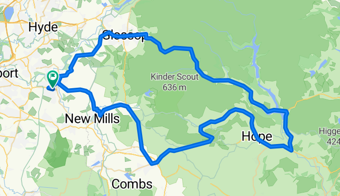
Marple-Edale ring
A cycling route starting in Marple, England, United Kingdom.
Overview
About this route
None (cloned from route 76320)
- -:--
- Duration
- 79.7 km
- Distance
- 1,022 m
- Ascent
- 1,019 m
- Descent
- ---
- Avg. speed
- ---
- Max. altitude

Route quality
Waytypes & surfaces along the route
Waytypes
Busy road
50.4 km
(63 %)
Road
21.8 km
(27 %)
Surfaces
Paved
37.6 km
(47 %)
Unpaved
0.3 km
(<1 %)
Asphalt
37.3 km
(47 %)
Paved (undefined)
0.2 km
(<1 %)
Continue with Bikemap
Use, edit, or download this cycling route
You would like to ride Marple-Edale ring or customize it for your own trip? Here is what you can do with this Bikemap route:
Free features
- Save this route as favorite or in collections
- Copy & plan your own version of this route
- Sync your route with Garmin or Wahoo
Premium features
Free trial for 3 days, or one-time payment. More about Bikemap Premium.
- Navigate this route on iOS & Android
- Export a GPX / KML file of this route
- Create your custom printout (try it for free)
- Download this route for offline navigation
Discover more Premium features.
Get Bikemap PremiumFrom our community
Other popular routes starting in Marple
 George Street, Romiley to George Street, Romiley
- Distance
- 5 km
- Ascent
- 114 m
- Descent
- 113 m
- Location
- Marple, England, United Kingdom
 Goyt Way
- Distance
- 42 km
- Ascent
- 515 m
- Descent
- 515 m
- Location
- Marple, England, United Kingdom
 Shrigley loop
- Distance
- 24.4 km
- Ascent
- 317 m
- Descent
- 317 m
- Location
- Marple, England, United Kingdom
 Marple-Edale ring
- Distance
- 79.6 km
- Ascent
- 1,146 m
- Descent
- 1,125 m
- Location
- Marple, England, United Kingdom
 Marple-Edale ring
- Distance
- 79.7 km
- Ascent
- 1,022 m
- Descent
- 1,019 m
- Location
- Marple, England, United Kingdom
 Goyt Vally Tour
- Distance
- 12.2 km
- Ascent
- 231 m
- Descent
- 230 m
- Location
- Marple, England, United Kingdom
 Training route
- Distance
- 33.6 km
- Ascent
- 138 m
- Descent
- 170 m
- Location
- Marple, England, United Kingdom
 Restful route in Stockport
- Distance
- 29.4 km
- Ascent
- 859 m
- Descent
- 859 m
- Location
- Marple, England, United Kingdom
Open it in the app