

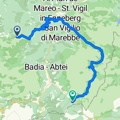
Wurzeljoch-Maureralm
A cycling route starting in San Martino in Badia, Trentino-Alto Adige, Italy.
Overview
About this route
Parking lot Gadertal St. Martin in Thurn Wurzeljoch-Maurerberg Almgasthof 2006 m Easy, 5 hours, 600 m elevation gain
- -:--
- Duration
- 11.6 km
- Distance
- 674 m
- Ascent
- 673 m
- Descent
- ---
- Avg. speed
- ---
- Max. altitude
Continue with Bikemap
Use, edit, or download this cycling route
You would like to ride Wurzeljoch-Maureralm or customize it for your own trip? Here is what you can do with this Bikemap route:
Free features
- Save this route as favorite or in collections
- Copy & plan your own version of this route
- Sync your route with Garmin or Wahoo
Premium features
Free trial for 3 days, or one-time payment. More about Bikemap Premium.
- Navigate this route on iOS & Android
- Export a GPX / KML file of this route
- Create your custom printout (try it for free)
- Download this route for offline navigation
Discover more Premium features.
Get Bikemap PremiumFrom our community
Other popular routes starting in San Martino in Badia
 Munt da Rina
- Distance
- 18.3 km
- Ascent
- 709 m
- Descent
- 723 m
- Location
- San Martino in Badia, Trentino-Alto Adige, Italy
 Rit tour
- Distance
- 26.4 km
- Ascent
- 1,713 m
- Descent
- 1,727 m
- Location
- San Martino in Badia, Trentino-Alto Adige, Italy
 St. Martin in Thurn - Corvara
- Distance
- 51.9 km
- Ascent
- 1,661 m
- Descent
- 2,066 m
- Location
- San Martino in Badia, Trentino-Alto Adige, Italy
 Dolomiten Trail Cross: Etappe 2: St. Martin - Arabba
- Distance
- 42.7 km
- Ascent
- 2,078 m
- Descent
- 1,609 m
- Location
- San Martino in Badia, Trentino-Alto Adige, Italy
 Passo delle erbe
- Distance
- 93 km
- Ascent
- 2,696 m
- Descent
- 2,694 m
- Location
- San Martino in Badia, Trentino-Alto Adige, Italy
 RoDa2019.5
- Distance
- 91.2 km
- Ascent
- 1,618 m
- Descent
- 2,197 m
- Location
- San Martino in Badia, Trentino-Alto Adige, Italy
 SSTT_2014_najezd
- Distance
- 74.4 km
- Ascent
- 1,727 m
- Descent
- 1,931 m
- Location
- San Martino in Badia, Trentino-Alto Adige, Italy
 2016 Alt 3
- Distance
- 103.9 km
- Ascent
- 2,392 m
- Descent
- 3,488 m
- Location
- San Martino in Badia, Trentino-Alto Adige, Italy
Open it in the app