

Flagogna - Plugna - Flagogna
A cycling route starting in Forgaria nel Friuli, Friuli Venezia Giulia, Italy.
Overview
About this route
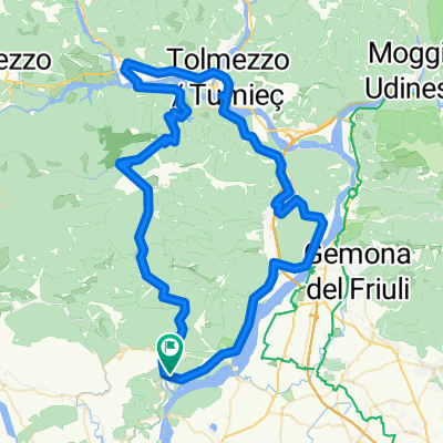
Flagogna: challenging climb up to Sella Chianzutan. Descent to Villa Santina. Climb through Lauco and its hamlet Vinaio, having crossed the Vinadia stream, continuing towards Plugna.
- -:--
- Duration
- 100.7 km
- Distance
- 1,648 m
- Ascent
- 1,651 m
- Descent
- ---
- Avg. speed
- ---
- Max. altitude

Route quality
Waytypes & surfaces along the route
Waytypes
Road
42.3 km
(42 %)
Quiet road
6 km
(6 %)
Surfaces
Paved
75.5 km
(75 %)
Asphalt
75.5 km
(75 %)
Undefined
25.2 km
(25 %)
Continue with Bikemap
Use, edit, or download this cycling route
You would like to ride Flagogna - Plugna - Flagogna or customize it for your own trip? Here is what you can do with this Bikemap route:
Free features
- Save this route as favorite or in collections
- Copy & plan your own version of this route
- Split it into stages to create a multi-day tour
- Sync your route with Garmin or Wahoo
Premium features
Free trial for 3 days, or one-time payment. More about Bikemap Premium.
- Navigate this route on iOS & Android
- Export a GPX / KML file of this route
- Create your custom printout (try it for free)
- Download this route for offline navigation
Discover more Premium features.
Get Bikemap PremiumFrom our community
Other popular routes starting in Forgaria nel Friuli
 Flagogna - Villa Santina - Cavazzo - Flagogna
- Distance
- 91.5 km
- Ascent
- 983 m
- Descent
- 984 m
- Location
- Forgaria nel Friuli, Friuli Venezia Giulia, Italy
 Monte Prat - Forcella
- Distance
- 37.9 km
- Ascent
- 1,269 m
- Descent
- 1,263 m
- Location
- Forgaria nel Friuli, Friuli Venezia Giulia, Italy
 giro del Monte San Simeone
- Distance
- 51.9 km
- Ascent
- 282 m
- Descent
- 291 m
- Location
- Forgaria nel Friuli, Friuli Venezia Giulia, Italy
 Cornino-Clauzetto-p.so Rest-Cavazzo
- Distance
- 107.5 km
- Ascent
- 1,504 m
- Descent
- 1,499 m
- Location
- Forgaria nel Friuli, Friuli Venezia Giulia, Italy
 Giro di Italia 2017, 19. etapa - 26. maj
- Distance
- 69.1 km
- Ascent
- 888 m
- Descent
- 894 m
- Location
- Forgaria nel Friuli, Friuli Venezia Giulia, Italy
 Friaul 2
- Distance
- 125.5 km
- Ascent
- 3,594 m
- Descent
- 3,574 m
- Location
- Forgaria nel Friuli, Friuli Venezia Giulia, Italy
 Strada di Bottecchia e lago di Cavazzo
- Distance
- 52.7 km
- Ascent
- 357 m
- Descent
- 372 m
- Location
- Forgaria nel Friuli, Friuli Venezia Giulia, Italy
 Forgaria nel Friuli - Meduno - Pradis 70
- Distance
- 71.5 km
- Ascent
- 1,945 m
- Descent
- 1,938 m
- Location
- Forgaria nel Friuli, Friuli Venezia Giulia, Italy
Open it in the app