

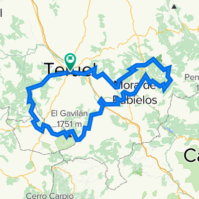
teruel valencia via verde
A cycling route starting in Teruel, Aragon, Spain.
Overview
About this route
verbinding girona-teruel naar valencia
- -:--
- Duration
- 163.1 km
- Distance
- 398 m
- Ascent
- 1,345 m
- Descent
- ---
- Avg. speed
- ---
- Avg. speed

Route quality
Waytypes & surfaces along the route
Waytypes
Track
74.6 km
(46 %)
Cycleway
36.1 km
(22 %)
Surfaces
Paved
94.6 km
(58 %)
Unpaved
10.8 km
(7 %)
Paved (undefined)
84.2 km
(52 %)
Asphalt
5.9 km
(4 %)
Continue with Bikemap
Use, edit, or download this cycling route
You would like to ride teruel valencia via verde or customize it for your own trip? Here is what you can do with this Bikemap route:
Free features
- Save this route as favorite or in collections
- Copy & plan your own version of this route
- Split it into stages to create a multi-day tour
- Sync your route with Garmin or Wahoo
Premium features
Free trial for 3 days, or one-time payment. More about Bikemap Premium.
- Navigate this route on iOS & Android
- Export a GPX / KML file of this route
- Create your custom printout (try it for free)
- Download this route for offline navigation
Discover more Premium features.
Get Bikemap PremiumFrom our community
Other popular routes starting in Teruel
 ESP 031: Via Verde Ojos Negros (Mittlerer Abschnitt)
- Distance
- 71.3 km
- Ascent
- 871 m
- Descent
- 871 m
- Location
- Teruel, Aragon, Spain
 Teruel - Mora de Rubielos
- Distance
- 48.5 km
- Ascent
- 508 m
- Descent
- 402 m
- Location
- Teruel, Aragon, Spain
 MINA DE OJOS NEGROS, TRAMO TERUEL-BARRACAS-JERICA
- Distance
- 98 km
- Ascent
- 774 m
- Descent
- 1,027 m
- Location
- Teruel, Aragon, Spain
 castelfabib>teruel
- Distance
- 276 km
- Ascent
- 6,300 m
- Descent
- 6,302 m
- Location
- Teruel, Aragon, Spain
 1 Teruel-Albarracín-Guadalaviar
- Distance
- 79.6 km
- Ascent
- 1,327 m
- Descent
- 667 m
- Location
- Teruel, Aragon, Spain
 Teruel-Sagunto
- Distance
- 149.5 km
- Ascent
- 379 m
- Descent
- 1,257 m
- Location
- Teruel, Aragon, Spain
 20100530-Via Verde
- Distance
- 132.7 km
- Ascent
- 358 m
- Descent
- 1,150 m
- Location
- Teruel, Aragon, Spain
 Teruel-MoraRubielos-Valdelinares-Teruel
- Distance
- 132.1 km
- Ascent
- 1,736 m
- Descent
- 1,726 m
- Location
- Teruel, Aragon, Spain
Open it in the app