

Les Tours et Portes du Bas-Rhin-boucle B
A cycling route starting in Strasbourg, Grand Est, France.
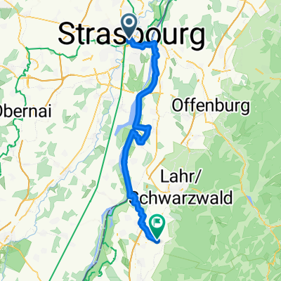
Overview
About this route
Circuit B
115 Km (tracé bleu pointillé + rouge)
19 villes ou villages
11 curiosités
Sommet le plus haut : Heiligenstein 300m
Dénivelé total : 520m
- -:--
- Duration
- 115.8 km
- Distance
- 351 m
- Ascent
- 350 m
- Descent
- ---
- Avg. speed
- ---
- Max. altitude

Route quality
Waytypes & surfaces along the route
Waytypes
Cycleway
18.5 km
(16 %)
Quiet road
17.4 km
(15 %)
Surfaces
Paved
77.6 km
(67 %)
Unpaved
6.9 km
(6 %)
Asphalt
74.1 km
(64 %)
Gravel
3.5 km
(3 %)
Continue with Bikemap
Use, edit, or download this cycling route
You would like to ride Les Tours et Portes du Bas-Rhin-boucle B or customize it for your own trip? Here is what you can do with this Bikemap route:
Free features
- Save this route as favorite or in collections
- Copy & plan your own version of this route
- Split it into stages to create a multi-day tour
- Sync your route with Garmin or Wahoo
Premium features
Free trial for 3 days, or one-time payment. More about Bikemap Premium.
- Navigate this route on iOS & Android
- Export a GPX / KML file of this route
- Create your custom printout (try it for free)
- Download this route for offline navigation
Discover more Premium features.
Get Bikemap PremiumFrom our community
Other popular routes starting in Strasbourg
 2005 Saar - Mosel
- Distance
- 486 km
- Ascent
- 417 m
- Descent
- 498 m
- Location
- Strasbourg, Grand Est, France
 Zomer 2017 - Strasbourg - Colmar (Eguisheim)
- Distance
- 82.5 km
- Ascent
- 94 m
- Descent
- 23 m
- Location
- Strasbourg, Grand Est, France
 1. Strasbourg - Ettenheim
- Distance
- 57.4 km
- Ascent
- 189 m
- Descent
- 164 m
- Location
- Strasbourg, Grand Est, France
 Grand tour Bruche et Marne au Rhin
- Distance
- 107.8 km
- Ascent
- 387 m
- Descent
- 388 m
- Location
- Strasbourg, Grand Est, France
 Strasbourg Drussenheim-Kehl-'Strasbourg
- Distance
- 66.4 km
- Ascent
- 64 m
- Descent
- 66 m
- Location
- Strasbourg, Grand Est, France
 Rue de l'Ail to Aristide Briand
- Distance
- 3.2 km
- Ascent
- 25 m
- Descent
- 35 m
- Location
- Strasbourg, Grand Est, France
 28 juin 2018
- Distance
- 48.3 km
- Ascent
- 64 m
- Descent
- 61 m
- Location
- Strasbourg, Grand Est, France
 "Moyen" Parcours Route
- Distance
- 40.9 km
- Ascent
- 213 m
- Descent
- 211 m
- Location
- Strasbourg, Grand Est, France
Open it in the app