

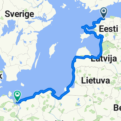
Tallinn-Narva
A cycling route starting in Tallinn, Harju, Estonia.
Overview
About this route
С 04.08.2011 по 08.08.2011
(cloned from route 965078)- -:--
- Duration
- 271.4 km
- Distance
- 262 m
- Ascent
- 248 m
- Descent
- ---
- Avg. speed
- ---
- Avg. speed
Route highlights
Points of interest along the route

Photo after 2.2 km
Памятник броненосцу "Русалка"

Photo after 5.7 km
Дорога в Пирита

Photo after 10.1 km
Развалины монастыря

Photo after 26.4 km
Дорога из Таллина

Photo after 29.3 km
Не всегда асфальт

Photo after 34 km
Кирха

Photo after 38 km
Водопад

Photo after 54 km
Старая башня в Кииу

Photo after 59.1 km
Аисты

Accommodation after 96.1 km
Кемпинг (палатка 3 человека с душем - 11 евро) Camping

Photo after 111.3 km
Мыза Sagadi

Photo after 139.9 km
Развалины крепости

Photo after 182.7 km
Крепость Purtse

Accommodation after 194.5 km
Кемпинг Saka

Photo after 194.7 km
Каскад в Сака

Photo after 205.3 km
Самый высокий водопад в Эстонии (но смотреть надо весной) Еще здесь же кемпинг (мы в нем не останавливались)

Accommodation after 217.4 km
Кемпинг Toila

Photo after 217.6 km
Берег в Тойла
Continue with Bikemap
Use, edit, or download this cycling route
You would like to ride Tallinn-Narva or customize it for your own trip? Here is what you can do with this Bikemap route:
Free features
- Save this route as favorite or in collections
- Copy & plan your own version of this route
- Split it into stages to create a multi-day tour
- Sync your route with Garmin or Wahoo
Premium features
Free trial for 3 days, or one-time payment. More about Bikemap Premium.
- Navigate this route on iOS & Android
- Export a GPX / KML file of this route
- Create your custom printout (try it for free)
- Download this route for offline navigation
Discover more Premium features.
Get Bikemap PremiumFrom our community
Other popular routes starting in Tallinn
 Rohumaa-Kaarli 1
- Distance
- 5 km
- Ascent
- 29 m
- Descent
- 3 m
- Location
- Tallinn, Harju, Estonia
 Route to Jagala Waterfall
- Distance
- 32.6 km
- Ascent
- 72 m
- Descent
- 46 m
- Location
- Tallinn, Harju, Estonia
 Route to Klaipeda
- Distance
- 893.7 km
- Ascent
- 3,828 m
- Descent
- 3,835 m
- Location
- Tallinn, Harju, Estonia
 Pirita-Lagedi-Peetri (GRV)
- Distance
- 53.4 km
- Ascent
- 160 m
- Descent
- 161 m
- Location
- Tallinn, Harju, Estonia
 Kadriorg-Viimsi-Noblessner (GRV)
- Distance
- 52.3 km
- Ascent
- 251 m
- Descent
- 247 m
- Location
- Tallinn, Harju, Estonia
 Radwanderung Tallinn - Riga - Palanga - Liepaja
- Distance
- 939.1 km
- Ascent
- 210 m
- Descent
- 219 m
- Location
- Tallinn, Harju, Estonia
 Tallin - Usedom
- Distance
- 1,967.9 km
- Ascent
- 549 m
- Descent
- 548 m
- Location
- Tallinn, Harju, Estonia
 Jāņi
Jāņi- Distance
- 469.5 km
- Ascent
- 368 m
- Descent
- 397 m
- Location
- Tallinn, Harju, Estonia
Open it in the app