

CANALE DEL BOSCO
A cycling route starting in Crocetta-Nogarè, Veneto, Italy.
Overview
About this route
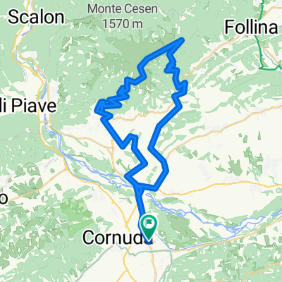
da Crocetta a Giavera sul versante meridionale del Montello
- -:--
- Duration
- 15.7 km
- Distance
- 59 m
- Ascent
- 137 m
- Descent
- ---
- Avg. speed
- ---
- Max. altitude

Route quality
Waytypes & surfaces along the route
Waytypes
Quiet road
12.1 km
(77 %)
Track
1.9 km
(12 %)
Surfaces
Paved
8.7 km
(55 %)
Unpaved
1.9 km
(12 %)
Asphalt
8.7 km
(55 %)
Loose gravel
1.2 km
(7 %)
Route highlights
Points of interest along the route
Point of interest after 0.2 km
BRENTELLA
Point of interest after 0.5 km
VILLA SANDI
Point of interest after 1.3 km
CIPPO AI CADUTI
Point of interest after 1.5 km
CANALE DEL BOSCO
Point of interest after 1.9 km
CANALE DEL BOSCO
Point of interest after 4.1 km
CANCELLI
Point of interest after 4.1 km
VILLA PISANI
Point of interest after 7.3 km
VENEGAZZU'
Point of interest after 7.8 km
VISIONI
Point of interest after 10.1 km
VOLPAGO
Point of interest after 12 km
SELVA DEL MONTELLO
Point of interest after 12.3 km
ZONA CASTELLO DEI VIDOTI - SELVA
Continue with Bikemap
Use, edit, or download this cycling route
You would like to ride CANALE DEL BOSCO or customize it for your own trip? Here is what you can do with this Bikemap route:
Free features
- Save this route as favorite or in collections
- Copy & plan your own version of this route
- Sync your route with Garmin or Wahoo
Premium features
Free trial for 3 days, or one-time payment. More about Bikemap Premium.
- Navigate this route on iOS & Android
- Export a GPX / KML file of this route
- Create your custom printout (try it for free)
- Download this route for offline navigation
Discover more Premium features.
Get Bikemap PremiumFrom our community
Other popular routes starting in Crocetta-Nogarè
 Via Erizzo 106B, Crocetta del Montello nach Via Cal de mezzo 1, Follina
- Distance
- 27.4 km
- Ascent
- 376 m
- Descent
- 303 m
- Location
- Crocetta-Nogarè, Veneto, Italy
 CROCETTA DEL MONTELLO
- Distance
- 45.1 km
- Ascent
- 525 m
- Descent
- 524 m
- Location
- Crocetta-Nogarè, Veneto, Italy
 Prova Crocetta
- Distance
- 50.1 km
- Ascent
- 1,024 m
- Descent
- 1,021 m
- Location
- Crocetta-Nogarè, Veneto, Italy
 MONTEBELLUNA IN BICICLETTA
- Distance
- 51.6 km
- Ascent
- 279 m
- Descent
- 280 m
- Location
- Crocetta-Nogarè, Veneto, Italy
 3 Tag Crocetta - Valdobiadene- Passo s.Boldo-Limana
- Distance
- 95.7 km
- Ascent
- 1,468 m
- Descent
- 1,261 m
- Location
- Crocetta-Nogarè, Veneto, Italy
 Pianezze da Crocetta
- Distance
- 52 km
- Ascent
- 1,237 m
- Descent
- 1,235 m
- Location
- Crocetta-Nogarè, Veneto, Italy
 MONTEBELLUNA IN BICICLETTA
- Distance
- 42 km
- Ascent
- 234 m
- Descent
- 280 m
- Location
- Crocetta-Nogarè, Veneto, Italy
 CANALE DEL BOSCO
- Distance
- 15.7 km
- Ascent
- 59 m
- Descent
- 137 m
- Location
- Crocetta-Nogarè, Veneto, Italy
Open it in the app