

Maare-Mosel-Radweg
A cycling route starting in Daun, Rhineland-Palatinate, Germany.
Overview
About this route
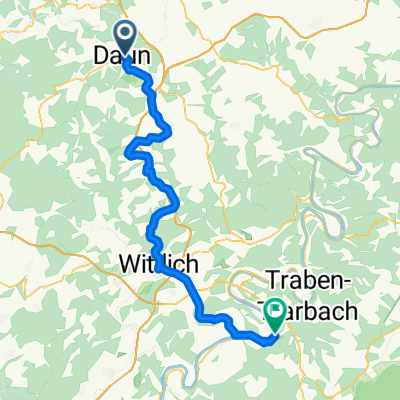
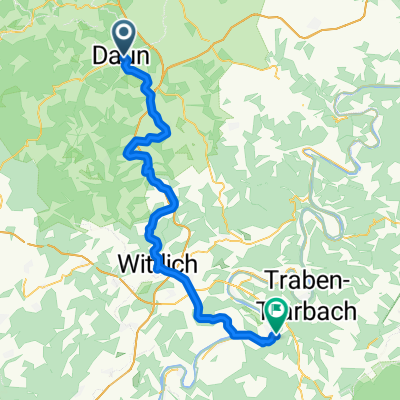
From Daun in the South Eifel, the route follows a former railway line down to the Moselle. The cycle path is very well developed. Highlights along the route include the old railway tunnels and the lava bomb in Strohn. A detour to one of the maars is also worthwhile.
How to get to Daun? A bike bus runs from Wittlich-Wengerohr station.
- -:--
- Duration
- 60.5 km
- Distance
- 281 m
- Ascent
- 519 m
- Descent
- ---
- Avg. speed
- ---
- Max. altitude
Route quality
Waytypes & surfaces along the route
Waytypes
Cycleway
38.7 km
(64 %)
Track
7.3 km
(12 %)
Surfaces
Paved
53.8 km
(89 %)
Unpaved
1.2 km
(2 %)
Asphalt
52.6 km
(87 %)
Paved (undefined)
1.2 km
(2 %)
Route highlights
Points of interest along the route
Point of interest after 2.8 km
Tunnel "Großes Schlitzohr"
Point of interest after 15.8 km
Lavabombe Strohn
Point of interest after 23.3 km
Bauernhofcafe
Point of interest after 38.2 km
Pleiner Tunnel
Point of interest after 56.6 km
Biergarten
Point of interest after 60.5 km
Pension
Continue with Bikemap
Use, edit, or download this cycling route
You would like to ride Maare-Mosel-Radweg or customize it for your own trip? Here is what you can do with this Bikemap route:
Free features
- Save this route as favorite or in collections
- Copy & plan your own version of this route
- Sync your route with Garmin or Wahoo
Premium features
Free trial for 3 days, or one-time payment. More about Bikemap Premium.
- Navigate this route on iOS & Android
- Export a GPX / KML file of this route
- Create your custom printout (try it for free)
- Download this route for offline navigation
Discover more Premium features.
Get Bikemap PremiumFrom our community
Other popular routes starting in Daun
 Pützborn-Schalkenmehren-Winkel-BadBertrich-Alf-Reil-Strotzbüsch-Gillenfeld-Gemünden-Pützborn
- Distance
- 108.1 km
- Ascent
- 940 m
- Descent
- 931 m
- Location
- Daun, Rhineland-Palatinate, Germany
 Maare-Mosel Radweg
- Distance
- 57.8 km
- Ascent
- 197 m
- Descent
- 469 m
- Location
- Daun, Rhineland-Palatinate, Germany
 Dauner Runde 1. Teil
- Distance
- 75.1 km
- Ascent
- 886 m
- Descent
- 877 m
- Location
- Daun, Rhineland-Palatinate, Germany
 L3110 - détour vers Dronke-Turm
- Distance
- 3.3 km
- Ascent
- 142 m
- Descent
- 142 m
- Location
- Daun, Rhineland-Palatinate, Germany
 Maare - Mosel
- Distance
- 59.8 km
- Ascent
- 254 m
- Descent
- 497 m
- Location
- Daun, Rhineland-Palatinate, Germany
 Daun nach Bernkastel 2016
- Distance
- 57.6 km
- Ascent
- 386 m
- Descent
- 675 m
- Location
- Daun, Rhineland-Palatinate, Germany
 Maare-Mosel-Radweg 090606
- Distance
- 58.2 km
- Ascent
- 370 m
- Descent
- 648 m
- Location
- Daun, Rhineland-Palatinate, Germany
 Maare - Mosel Bahntrasse
- Distance
- 59.7 km
- Ascent
- 400 m
- Descent
- 665 m
- Location
- Daun, Rhineland-Palatinate, Germany
Open it in the app