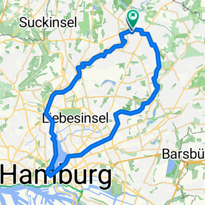
Alsterwanderweg
A cycling route starting in Poppenbüttel, City state of Hamburg, Germany.
Overview
About this route
The tour takes you from the outskirts along a natural valley area into the city to Hamburg's Rathausmarkt. The Alster valley is now fully developed for recreation both on land and on the water. You will find wet meadows and floodplain forests here, leading up to the promenade at the Alster arcades in the city centre.
- -:--
- Duration
- 19 km
- Distance
- 23 m
- Ascent
- 44 m
- Descent
- ---
- Avg. speed
- ---
- Max. altitude
Route quality
Waytypes & surfaces along the route
Waytypes
Pedestrian area
11.8 km
(62 %)
Quiet road
4.4 km
(23 %)
Surfaces
Paved
6.7 km
(35 %)
Unpaved
11.2 km
(59 %)
Gravel
8 km
(42 %)
Asphalt
6.7 km
(35 %)
Route highlights
Points of interest along the route
Point of interest after 3.5 km
Torhaus Wellingsbüttel
Point of interest after 7.1 km
Großer Spielplatz an der Alster
Point of interest after 8.1 km
Kanuclub mit Einkehrmöglichkeit
Point of interest after 8.4 km
Spielplatz
Point of interest after 8.6 km
Kanuverleih
Point of interest after 8.6 km
Einkehrmöglichkeit
Point of interest after 9 km
Hallen- und Freibad Ohlsdorf
Point of interest after 9.1 km
Ohlsdorfer Alsterschleuse
Point of interest after 9.4 km
Spielplatz
Point of interest after 13.4 km
Großer Spielplatz
Point of interest after 13.8 km
Badestelle (für die ganz Kleinen)
Point of interest after 13.9 km
Spielplatz
Point of interest after 14.5 km
Einkehrmöglichkeit
Point of interest after 15.9 km
Kanuverleih; Einkehrmöglichkeit
Continue with Bikemap
Use, edit, or download this cycling route
You would like to ride Alsterwanderweg or customize it for your own trip? Here is what you can do with this Bikemap route:
Free features
- Save this route as favorite or in collections
- Copy & plan your own version of this route
- Sync your route with Garmin or Wahoo
Premium features
Free trial for 3 days, or one-time payment. More about Bikemap Premium.
- Navigate this route on iOS & Android
- Export a GPX / KML file of this route
- Create your custom printout (try it for free)
- Download this route for offline navigation
Discover more Premium features.
Get Bikemap PremiumFrom our community
Other popular routes starting in Poppenbüttel
 Poppenbütteler Berg Suelfeld und zurueck
- Distance
- 51.3 km
- Ascent
- 117 m
- Descent
- 111 m
- Location
- Poppenbüttel, City state of Hamburg, Germany
 Alsterwanderweg
- Distance
- 40.1 km
- Ascent
- 101 m
- Descent
- 107 m
- Location
- Poppenbüttel, City state of Hamburg, Germany
 Feierabendrunde - schnelle Duvenstedter
- Distance
- 25.1 km
- Ascent
- 84 m
- Descent
- 83 m
- Location
- Poppenbüttel, City state of Hamburg, Germany
 87 km bis Todesfelde
- Distance
- 86.9 km
- Ascent
- 270 m
- Descent
- 271 m
- Location
- Poppenbüttel, City state of Hamburg, Germany
 Hamburg Radtour 4: Oberalster
- Distance
- 26.9 km
- Ascent
- 77 m
- Descent
- 81 m
- Location
- Poppenbüttel, City state of Hamburg, Germany
 Rudi-Bode RTF
- Distance
- 151.8 km
- Ascent
- 356 m
- Descent
- 354 m
- Location
- Poppenbüttel, City state of Hamburg, Germany
 Poptownrunde
- Distance
- 43.7 km
- Ascent
- 108 m
- Descent
- 105 m
- Location
- Poppenbüttel, City state of Hamburg, Germany
 Ruhige Stunde
- Distance
- 34.5 km
- Ascent
- 107 m
- Descent
- 106 m
- Location
- Poppenbüttel, City state of Hamburg, Germany
Open it in the app

