

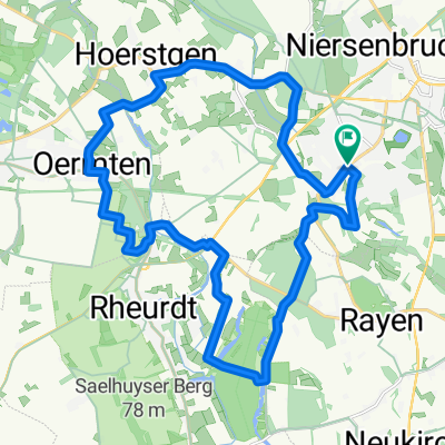
Die Baumkreisroute 41 km Klosterstraße
A cycling route starting in Kamp-Lintfort, North Rhine-Westphalia, Germany.
Overview
About this route
Die Baumkreisroute 41 km Klosterstraße Parkplatz Start
- -:--
- Duration
- 41 km
- Distance
- 77 m
- Ascent
- 77 m
- Descent
- ---
- Avg. speed
- ---
- Max. altitude
Route quality
Waytypes & surfaces along the route
Waytypes
Quiet road
22.1 km
(54 %)
Path
6.6 km
(16 %)
Surfaces
Paved
22.9 km
(56 %)
Unpaved
2.5 km
(6 %)
Asphalt
22.1 km
(54 %)
Gravel
2 km
(5 %)
Route highlights
Points of interest along the route
Point of interest after 5.6 km
Point of interest after 7.4 km
Continue with Bikemap
Use, edit, or download this cycling route
You would like to ride Die Baumkreisroute 41 km Klosterstraße or customize it for your own trip? Here is what you can do with this Bikemap route:
Free features
- Save this route as favorite or in collections
- Copy & plan your own version of this route
- Sync your route with Garmin or Wahoo
Premium features
Free trial for 3 days, or one-time payment. More about Bikemap Premium.
- Navigate this route on iOS & Android
- Export a GPX / KML file of this route
- Create your custom printout (try it for free)
- Download this route for offline navigation
Discover more Premium features.
Get Bikemap PremiumFrom our community
Other popular routes starting in Kamp-Lintfort
 Die Leucht-Route
- Distance
- 24.8 km
- Ascent
- 101 m
- Descent
- 103 m
- Location
- Kamp-Lintfort, North Rhine-Westphalia, Germany
 Die Leucht 3
- Distance
- 32 km
- Ascent
- 123 m
- Descent
- 125 m
- Location
- Kamp-Lintfort, North Rhine-Westphalia, Germany
 Lintfort - Oermter Berg - Lintfort
- Distance
- 23.3 km
- Ascent
- 86 m
- Descent
- 85 m
- Location
- Kamp-Lintfort, North Rhine-Westphalia, Germany
 Frankys Runde, Pattberg, Homberg,Essenberg, Kaßlerfeld, Walsum, Orsoy, Budberg, Pattberg
- Distance
- 52.5 km
- Ascent
- 124 m
- Descent
- 122 m
- Location
- Kamp-Lintfort, North Rhine-Westphalia, Germany
 Sakrale Bauten am Niederrhein
- Distance
- 63.5 km
- Ascent
- 124 m
- Descent
- 167 m
- Location
- Kamp-Lintfort, North Rhine-Westphalia, Germany
 Route Kohlenhuk
- Distance
- 26.1 km
- Ascent
- 97 m
- Descent
- 98 m
- Location
- Kamp-Lintfort, North Rhine-Westphalia, Germany
 Lintfort-Tour by O.Broll
- Distance
- 24.8 km
- Ascent
- 32 m
- Descent
- 27 m
- Location
- Kamp-Lintfort, North Rhine-Westphalia, Germany
 Kamp_Lintfort - Xanten um Nord und Südsee
- Distance
- 61.4 km
- Ascent
- 196 m
- Descent
- 196 m
- Location
- Kamp-Lintfort, North Rhine-Westphalia, Germany
Open it in the app