

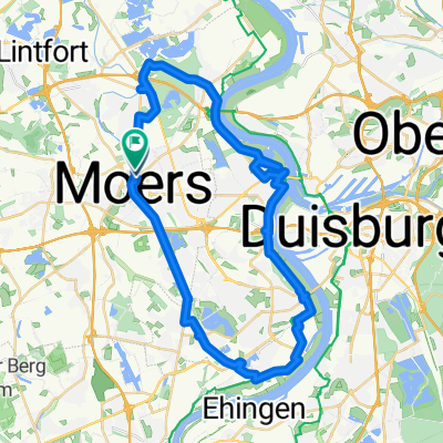
Rundweg Moers-Rheinauen-Töppersee
A cycling route starting in Moers, North Rhine-Westphalia, Germany.
Overview
About this route
The route starts in the Schwafheim recreation area, then across the Schafheimer Meer to Elfrather See, continuing to the Rhine floodplains at Friesersheim to the restaurant at Töppersee (about 2 hours). After the refreshment break, return to the starting point in 1 hour.
- -:--
- Duration
- 40.6 km
- Distance
- 43 m
- Ascent
- 39 m
- Descent
- ---
- Avg. speed
- ---
- Max. altitude
Route quality
Waytypes & surfaces along the route
Waytypes
Quiet road
13 km
(32 %)
Track
11.8 km
(29 %)
Surfaces
Paved
16.6 km
(41 %)
Unpaved
12.6 km
(31 %)
Asphalt
16.2 km
(40 %)
Gravel
7.3 km
(18 %)
Route highlights
Points of interest along the route
Point of interest after 27.6 km
Restaurant
Continue with Bikemap
Use, edit, or download this cycling route
You would like to ride Rundweg Moers-Rheinauen-Töppersee or customize it for your own trip? Here is what you can do with this Bikemap route:
Free features
- Save this route as favorite or in collections
- Copy & plan your own version of this route
- Sync your route with Garmin or Wahoo
Premium features
Free trial for 3 days, or one-time payment. More about Bikemap Premium.
- Navigate this route on iOS & Android
- Export a GPX / KML file of this route
- Create your custom printout (try it for free)
- Download this route for offline navigation
Discover more Premium features.
Get Bikemap PremiumFrom our community
Other popular routes starting in Moers
 Oranier-Fahrradroute: Abschnitt Moers - Apeldoorn / Oranjefietsroute: Traject Moers – Apeldoorn
- Distance
- 230.7 km
- Ascent
- 663 m
- Descent
- 671 m
- Location
- Moers, North Rhine-Westphalia, Germany
 Wachtendonk - Erkelenz
- Distance
- 27.5 km
- Ascent
- 79 m
- Descent
- 64 m
- Location
- Moers, North Rhine-Westphalia, Germany
 Krickenbecker seen, de wittsee
- Distance
- 68.4 km
- Ascent
- 236 m
- Descent
- 235 m
- Location
- Moers, North Rhine-Westphalia, Germany
 Duisburg nach Straelen Tag 1
- Distance
- 58.9 km
- Ascent
- 135 m
- Descent
- 119 m
- Location
- Moers, North Rhine-Westphalia, Germany
 Rheinberger Straße nach Moers Baerler Straße
- Distance
- 43.9 km
- Ascent
- 105 m
- Descent
- 107 m
- Location
- Moers, North Rhine-Westphalia, Germany
 Niederrheinischer Radwandertag Route 15
- Distance
- 43.5 km
- Ascent
- 39 m
- Descent
- 38 m
- Location
- Moers, North Rhine-Westphalia, Germany
 Feierabendtour
- Distance
- 28.1 km
- Ascent
- 50 m
- Descent
- 53 m
- Location
- Moers, North Rhine-Westphalia, Germany
 Oranier-Fahrradroute: Abschnitt Moers - Apeldoorn / Oranjefietsroute: Traject Moers – Apeldoorn
- Distance
- 230.7 km
- Ascent
- 665 m
- Descent
- 665 m
- Location
- Moers, North Rhine-Westphalia, Germany
Open it in the app