信楽駅ーミホ・ミュージアム−草津
A cycling route starting in Minakuchichō-matoba, Shiga Prefecture, Japan.
Overview
About this route
信楽駅ーミホ・ミュージアム−草津
- -:--
- Duration
- 30.8 km
- Distance
- 307 m
- Ascent
- 502 m
- Descent
- ---
- Avg. speed
- ---
- Avg. speed
Route quality
Waytypes & surfaces along the route
Waytypes
Quiet road
14.2 km
(46 %)
Road
9 km
(29 %)
Surfaces
Paved
10.4 km
(34 %)
Paved (undefined)
10.4 km
(34 %)
Undefined
20.3 km
(66 %)
Continue with Bikemap
Use, edit, or download this cycling route
You would like to ride 信楽駅ーミホ・ミュージアム−草津 or customize it for your own trip? Here is what you can do with this Bikemap route:
Free features
- Save this route as favorite or in collections
- Copy & plan your own version of this route
- Sync your route with Garmin or Wahoo
Premium features
Free trial for 3 days, or one-time payment. More about Bikemap Premium.
- Navigate this route on iOS & Android
- Export a GPX / KML file of this route
- Create your custom printout (try it for free)
- Download this route for offline navigation
Discover more Premium features.
Get Bikemap PremiumFrom our community
Other popular routes starting in Minakuchichō-matoba
- to camp
- Distance
- 29 km
- Ascent
- 113 m
- Descent
- 203 m
- Location
- Minakuchichō-matoba, Shiga Prefecture, Japan
- 国道307号, Koka to 1393, Murai, Hino, Gamo-Gun
- Distance
- 37.5 km
- Ascent
- 1,115 m
- Descent
- 1,097 m
- Location
- Minakuchichō-matoba, Shiga Prefecture, Japan
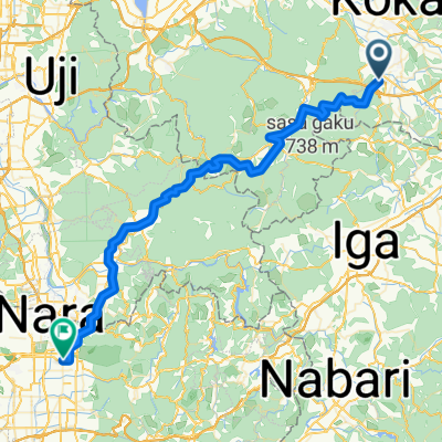
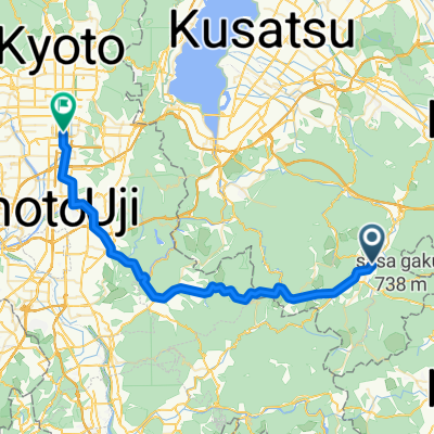
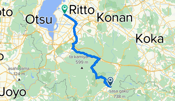
- 1018, Minakuchichomushono, Koka to 1-16, Shibukawa 1-Chōme, Kusatsu
- Distance
- 23.8 km
- Ascent
- 80 m
- Descent
- 154 m
- Location
- Minakuchichō-matoba, Shiga Prefecture, Japan
- 旧東海道自転車の旅~Day 7
- Distance
- 57.3 km
- Ascent
- 173 m
- Descent
- 280 m
- Location
- Minakuchichō-matoba, Shiga Prefecture, Japan
- Kamitomoda, Iga to Midai, Iga
- Distance
- 10.2 km
- Ascent
- 116 m
- Descent
- 117 m
- Location
- Minakuchichō-matoba, Shiga Prefecture, Japan
- 梅影町4-2, 湖南市 to 水口町水口5587-3, 甲賀市
- Distance
- 13.6 km
- Ascent
- 1,845 m
- Descent
- 1,829 m
- Location
- Minakuchichō-matoba, Shiga Prefecture, Japan
- 甲賀コース(忍びの里サイクリングコース)
- Distance
- 37 km
- Ascent
- 169 m
- Descent
- 169 m
- Location
- Minakuchichō-matoba, Shiga Prefecture, Japan
- Location3
- Distance
- 21.9 km
- Ascent
- 526 m
- Descent
- 207 m
- Location
- Minakuchichō-matoba, Shiga Prefecture, Japan
Open it in the app