

Ronneburgrunde - ca. 550 Hm
A cycling route starting in Bad Vilbel, Hesse, Germany.
Overview
About this route
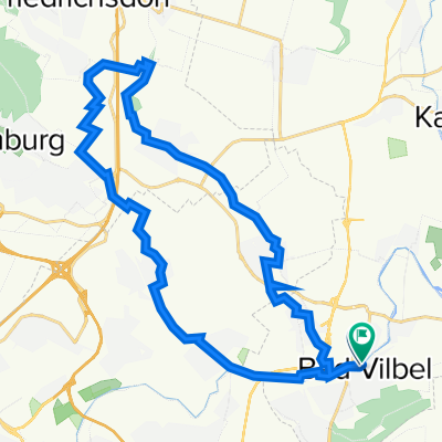
<span style="color: #000000; font-family: arial, helvetica, sans-serif; font-size: 13px;">BV-Kreisel -> Niederdorfelden -> Wachenbuchen -> Mittelbuchen -> Bruchköbel -> Erlensee -> Ravolzhausen -> Hüttengesäß -> Altwiedermus -> Ronneburg -> Eckhartshausen -> Himbach -> Rommelshausen -> Altenstadt -> Stammheim -> Flörstadt -> Wickstadt -> Assenheim -> Wöllstadt -> Rodheim -> Burgholzhausen -> Ober-Erlenbach -> Nieder-Eschbach -> Nieder-Erlenbach -> BV-Kreisel</span>
- -:--
- Duration
- 87.9 km
- Distance
- 596 m
- Ascent
- 564 m
- Descent
- ---
- Avg. speed
- 234 m
- Max. altitude
Route quality
Waytypes & surfaces along the route
Waytypes
Busy road
37.3 km
(42 %)
Road
20.3 km
(23 %)
Surfaces
Paved
78.7 km
(90 %)
Unpaved
3.1 km
(4 %)
Asphalt
72.7 km
(83 %)
Paving stones
5.6 km
(6 %)
Continue with Bikemap
Use, edit, or download this cycling route
You would like to ride Ronneburgrunde - ca. 550 Hm or customize it for your own trip? Here is what you can do with this Bikemap route:
Free features
- Save this route as favorite or in collections
- Copy & plan your own version of this route
- Split it into stages to create a multi-day tour
- Sync your route with Garmin or Wahoo
Premium features
Free trial for 3 days, or one-time payment. More about Bikemap Premium.
- Navigate this route on iOS & Android
- Export a GPX / KML file of this route
- Create your custom printout (try it for free)
- Download this route for offline navigation
Discover more Premium features.
Get Bikemap PremiumFrom our community
Other popular routes starting in Bad Vilbel
 Rundroute Bad Vilbel - Bad Homburg
- Distance
- 37.3 km
- Ascent
- 268 m
- Descent
- 269 m
- Location
- Bad Vilbel, Hesse, Germany
 RTF Niedererlenbach 114km Runde
- Distance
- 116 km
- Ascent
- 940 m
- Descent
- 928 m
- Location
- Bad Vilbel, Hesse, Germany
 Ronneburgrunde - ca. 550 Hm
- Distance
- 87.9 km
- Ascent
- 596 m
- Descent
- 564 m
- Location
- Bad Vilbel, Hesse, Germany
 Bad Vilbel - Bonames - Weißkirchen - Ober Eschbach - Ober-Erlenbach - Nieder-Erlenbach - Bad Vilbel
- Distance
- 31.2 km
- Ascent
- 130 m
- Descent
- 124 m
- Location
- Bad Vilbel, Hesse, Germany
 Eschbach-Erlenbach
- Distance
- 26.8 km
- Ascent
- 92 m
- Descent
- 91 m
- Location
- Bad Vilbel, Hesse, Germany
 Rundkurs ab Enkheim
- Distance
- 47.8 km
- Ascent
- 278 m
- Descent
- 285 m
- Location
- Bad Vilbel, Hesse, Germany
 Ronneburgrunde südlich (RB 073 - 0340)
- Distance
- 73.2 km
- Ascent
- 321 m
- Descent
- 321 m
- Location
- Bad Vilbel, Hesse, Germany
 Afterworkroute 5 - ca. 190 Hm
- Distance
- 40.4 km
- Ascent
- 238 m
- Descent
- 224 m
- Location
- Bad Vilbel, Hesse, Germany
Open it in the app