

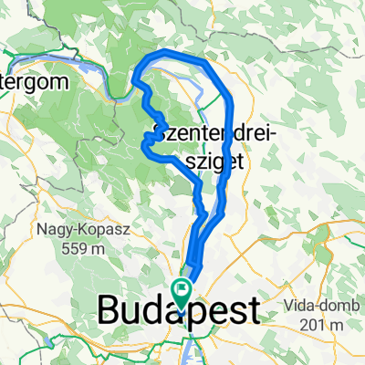
Otthon - Pilisvörösvár - Pomáz - Capital
A cycling route starting in Budapest, Budapest, Hungary.
Overview
About this route
Otthon - Pilisvörösvár - Pomáz - Capital
- -:--
- Duration
- 60 km
- Distance
- 481 m
- Ascent
- 540 m
- Descent
- ---
- Avg. speed
- ---
- Max. altitude

Route quality
Waytypes & surfaces along the route
Waytypes
Quiet road
24.6 km
(41 %)
Road
9 km
(15 %)
Surfaces
Paved
45 km
(75 %)
Unpaved
1.8 km
(3 %)
Asphalt
43.2 km
(72 %)
Paved (undefined)
1.8 km
(3 %)
Continue with Bikemap
Use, edit, or download this cycling route
You would like to ride Otthon - Pilisvörösvár - Pomáz - Capital or customize it for your own trip? Here is what you can do with this Bikemap route:
Free features
- Save this route as favorite or in collections
- Copy & plan your own version of this route
- Sync your route with Garmin or Wahoo
Premium features
Free trial for 3 days, or one-time payment. More about Bikemap Premium.
- Navigate this route on iOS & Android
- Export a GPX / KML file of this route
- Create your custom printout (try it for free)
- Download this route for offline navigation
Discover more Premium features.
Get Bikemap PremiumFrom our community
Other popular routes starting in Budapest
 Route in Budapest, 100km
- Distance
- 100 km
- Ascent
- 374 m
- Descent
- 373 m
- Location
- Budapest, Budapest, Hungary
 Országos Kerékpáros Körtúra
- Distance
- 4,568.5 km
- Ascent
- 1,637 m
- Descent
- 1,641 m
- Location
- Budapest, Budapest, Hungary
 Tour de Rose
- Distance
- 11.9 km
- Ascent
- 49 m
- Descent
- 63 m
- Location
- Budapest, Budapest, Hungary
 Krisztina körút, Budapest to Pannónia utca, Budapest
- Distance
- 20 km
- Ascent
- 147 m
- Descent
- 151 m
- Location
- Budapest, Budapest, Hungary
 100k With Climb
- Distance
- 104.1 km
- Ascent
- 922 m
- Descent
- 922 m
- Location
- Budapest, Budapest, Hungary
 Vitéz utca 5, Budapest to Vitéz utca 5, Budapest
- Distance
- 78.8 km
- Ascent
- 613 m
- Descent
- 613 m
- Location
- Budapest, Budapest, Hungary
 Route from Budapest
- Distance
- 1,362.6 km
- Ascent
- 11,921 m
- Descent
- 12,009 m
- Location
- Budapest, Budapest, Hungary
 District V, Budapest to Pannónia utca, Budapest
- Distance
- 6.8 km
- Ascent
- 52 m
- Descent
- 40 m
- Location
- Budapest, Budapest, Hungary
Open it in the app