
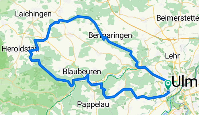
Sontheimer Höhle
A cycling route starting in Ulm, Baden-Wurttemberg, Germany.
Overview
About this route
- -:--
- Duration
- 68.7 km
- Distance
- 604 m
- Ascent
- 604 m
- Descent
- ---
- Avg. speed
- ---
- Max. altitude

Continue with Bikemap
Use, edit, or download this cycling route
You would like to ride Sontheimer Höhle or customize it for your own trip? Here is what you can do with this Bikemap route:
Free features
- Save this route as favorite or in collections
- Copy & plan your own version of this route
- Sync your route with Garmin or Wahoo
Premium features
Free trial for 3 days, or one-time payment. More about Bikemap Premium.
- Navigate this route on iOS & Android
- Export a GPX / KML file of this route
- Create your custom printout (try it for free)
- Download this route for offline navigation
Discover more Premium features.
Get Bikemap PremiumFrom our community
Other popular routes starting in Ulm
 E5. 9.7.25 Ulm nach Donauwörth
- Distance
- 96.5 km
- Ascent
- 254 m
- Descent
- 369 m
- Location
- Ulm, Baden-Wurttemberg, Germany
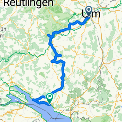
 Ulm-Bodensee Runde
- Distance
- 235.6 km
- Ascent
- 1,596 m
- Descent
- 1,576 m
- Location
- Ulm, Baden-Wurttemberg, Germany
 Teil 1 - 31. August bis 05. September
- Distance
- 557.1 km
- Ascent
- 7,016 m
- Descent
- 7,420 m
- Location
- Ulm, Baden-Wurttemberg, Germany
 Zuhause-Kleines Lautertal-Bollingen-Zuhause_2024
- Distance
- 32.8 km
- Ascent
- 489 m
- Descent
- 492 m
- Location
- Ulm, Baden-Wurttemberg, Germany
 Let's go
- Distance
- 516.9 km
- Ascent
- 6,839 m
- Descent
- 7,253 m
- Location
- Ulm, Baden-Wurttemberg, Germany
 Ulm - Bodensee
- Distance
- 173.1 km
- Ascent
- 548 m
- Descent
- 622 m
- Location
- Ulm, Baden-Wurttemberg, Germany
 Blaustein-Örlingen-Donau
- Distance
- 28.9 km
- Ascent
- 222 m
- Descent
- 219 m
- Location
- Ulm, Baden-Wurttemberg, Germany
 BBB-Runde
- Distance
- 60.6 km
- Ascent
- 969 m
- Descent
- 919 m
- Location
- Ulm, Baden-Wurttemberg, Germany
Open it in the app