Von Gambach nach Schotten durch den Naturpark Hoher Vogelsberg
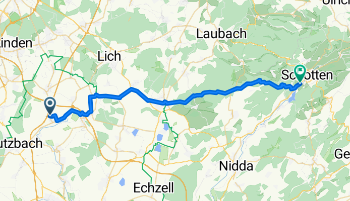
A cycling route starting in Münzenberg, Hesse, Germany.
Overview
About this route
From Gambach to Hungen, the route is paved. From Hungen to just before Schotten, it’s only gravel, partly coarse and partly fine gravel.
The climbs aren’t as steep for my strength as I initially thought.
- -:--
- Duration
- 34.9 km
- Distance
- 361 m
- Ascent
- 266 m
- Descent
- ---
- Avg. speed
- ---
- Max. altitude
Continue with Bikemap
Use, edit, or download this cycling route
You would like to ride Von Gambach nach Schotten durch den Naturpark Hoher Vogelsberg or customize it for your own trip? Here is what you can do with this Bikemap route:
Free features
- Save this route as favorite or in collections
- Copy & plan your own version of this route
- Sync your route with Garmin or Wahoo
Premium features
Free trial for 3 days, or one-time payment. More about Bikemap Premium.
- Navigate this route on iOS & Android
- Export a GPX / KML file of this route
- Create your custom printout (try it for free)
- Download this route for offline navigation
Discover more Premium features.
Get Bikemap PremiumFrom our community
Other popular routes starting in Münzenberg
- Rundtour zum Hausberg
- Distance
- 28.3 km
- Ascent
- 450 m
- Descent
- 441 m
- Location
- Münzenberg, Hesse, Germany
- Wetterau 01
- Distance
- 32.8 km
- Ascent
- 255 m
- Descent
- 266 m
- Location
- Münzenberg, Hesse, Germany
- von Ober Hörgern zum Butzbacher Schwimmbad
- Distance
- 21.8 km
- Ascent
- 218 m
- Descent
- 177 m
- Location
- Münzenberg, Hesse, Germany
- Radtour2020-Etappe-1
- Distance
- 59.9 km
- Ascent
- 170 m
- Descent
- 191 m
- Location
- Münzenberg, Hesse, Germany
- Trainingsstrecke Napoleonstock
- Distance
- 42.3 km
- Ascent
- 377 m
- Descent
- 376 m
- Location
- Münzenberg, Hesse, Germany
- Wölfersheimer See
- Distance
- 20.3 km
- Ascent
- 130 m
- Descent
- 135 m
- Location
- Münzenberg, Hesse, Germany
- Steinbruch
- Distance
- 37.4 km
- Ascent
- 128 m
- Descent
- 127 m
- Location
- Münzenberg, Hesse, Germany
- Eberstadt, Holzheim, Kirch/PohlGöns, Griedel Rockenberg, Münzenberg, Eberstadt
- Distance
- 29.7 km
- Ascent
- 284 m
- Descent
- 283 m
- Location
- Münzenberg, Hesse, Germany
Open it in the app