

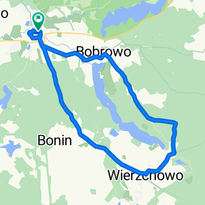
Szlak Dookoła Jeziora Siecino
A cycling route starting in Złocieniec, West Pomeranian Voivodeship, Poland.
Overview
About this route
Trail Around Lake Siecino
- -:--
- Duration
- 40.8 km
- Distance
- 220 m
- Ascent
- 219 m
- Descent
- ---
- Avg. speed
- ---
- Max. altitude

Route quality
Waytypes & surfaces along the route
Waytypes
Quiet road
12.7 km
(31 %)
Road
11.8 km
(29 %)
Surfaces
Paved
28.6 km
(70 %)
Unpaved
1.6 km
(4 %)
Asphalt
28.2 km
(69 %)
Gravel
1.2 km
(3 %)
Continue with Bikemap
Use, edit, or download this cycling route
You would like to ride Szlak Dookoła Jeziora Siecino or customize it for your own trip? Here is what you can do with this Bikemap route:
Free features
- Save this route as favorite or in collections
- Copy & plan your own version of this route
- Sync your route with Garmin or Wahoo
Premium features
Free trial for 3 days, or one-time payment. More about Bikemap Premium.
- Navigate this route on iOS & Android
- Export a GPX / KML file of this route
- Create your custom printout (try it for free)
- Download this route for offline navigation
Discover more Premium features.
Get Bikemap PremiumFrom our community
Other popular routes starting in Złocieniec
 Złocieniec-Połczyn 70km
- Distance
- 69 km
- Ascent
- 427 m
- Descent
- 428 m
- Location
- Złocieniec, West Pomeranian Voivodeship, Poland
 Dolina_Wasawy
- Distance
- 26.9 km
- Ascent
- 130 m
- Descent
- 130 m
- Location
- Złocieniec, West Pomeranian Voivodeship, Poland
 Złociec-Połczyn Z.
- Distance
- 71.9 km
- Ascent
- 319 m
- Descent
- 318 m
- Location
- Złocieniec, West Pomeranian Voivodeship, Poland
 Cieszyno - Kołobrzeg
- Distance
- 115 km
- Ascent
- 555 m
- Descent
- 681 m
- Location
- Złocieniec, West Pomeranian Voivodeship, Poland
 Złocieniec - Drawsko
- Distance
- 98.4 km
- Ascent
- 249 m
- Descent
- 265 m
- Location
- Złocieniec, West Pomeranian Voivodeship, Poland
 Szlak Dookoła Jeziora Siecino
- Distance
- 40.8 km
- Ascent
- 220 m
- Descent
- 219 m
- Location
- Złocieniec, West Pomeranian Voivodeship, Poland
 Pętla dookoła jeziora Lubie Lubieszewo - Lubieszewo
- Distance
- 42.2 km
- Ascent
- 419 m
- Descent
- 415 m
- Location
- Złocieniec, West Pomeranian Voivodeship, Poland
 44A, Lubieszewo do 44A, Lubieszewo
- Distance
- 26.6 km
- Ascent
- 315 m
- Descent
- 312 m
- Location
- Złocieniec, West Pomeranian Voivodeship, Poland
Open it in the app