

Po pracy drogą okrężną :)
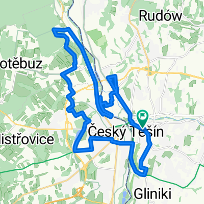
A cycling route starting in Cieszyn, Silesian Voivodeship, Poland.
Overview
About this route
Cieszyn > Dzięgielów > Cisownica > Ustroń > Wisła > Przełęcz Kubalonka > Istebna > Jasnowice > Jabłonków > Bystrzyca > Trzyniec > Cieszyn 10.04.15
- -:--
- Duration
- 80.9 km
- Distance
- 725 m
- Ascent
- 725 m
- Descent
- ---
- Avg. speed
- ---
- Max. altitude

Route quality
Waytypes & surfaces along the route
Waytypes
Road
18.6 km
(23 %)
Quiet road
18.6 km
(23 %)
Surfaces
Paved
51.7 km
(64 %)
Unpaved
0.8 km
(1 %)
Asphalt
51.7 km
(64 %)
Ground
0.8 km
(1 %)
Undefined
28.3 km
(35 %)
Route highlights
Points of interest along the route
\"")
Photo after 4.8 km
Puńców
\"")
Point of interest after 17.3 km
\"")
Photo after 26 km
Wisła
\"")
Photo after 33.7 km
"patelnia"
\"")
Point of interest after 35.3 km
Przełęcz Kubalonka 761 m n.p.m.
\"")
Photo after 40.4 km
w drodze do centrum Istebnej
\"")
Photo after 42.7 km
Istebna, Chata u Kawuloka
\"")
Photo after 44.2 km
Ochodzita
\"")
Photo after 44.3 km
widok na Baranią Górę
Drinking water after 46 km
sklep
\"")
Photo after 50.2 km
zjazd do Bukovca
\"")
Photo after 50.6 km
\"")
Photo after 52.5 km
U Turka
\"")
Photo after 63.3 km
\"")
Drinking water after 71 km
\"")
Photo after 79.2 km
Czeski Cieszyn, Park Sikory
Continue with Bikemap
Use, edit, or download this cycling route
You would like to ride Po pracy drogą okrężną :) or customize it for your own trip? Here is what you can do with this Bikemap route:
Free features
- Save this route as favorite or in collections
- Copy & plan your own version of this route
- Split it into stages to create a multi-day tour
- Sync your route with Garmin or Wahoo
Premium features
Free trial for 3 days, or one-time payment. More about Bikemap Premium.
- Navigate this route on iOS & Android
- Export a GPX / KML file of this route
- Create your custom printout (try it for free)
- Download this route for offline navigation
Discover more Premium features.
Get Bikemap PremiumFrom our community
Other popular routes starting in Cieszyn
 Kubalonka - inaczej, trudniej !
- Distance
- 88.1 km
- Ascent
- 714 m
- Descent
- 714 m
- Location
- Cieszyn, Silesian Voivodeship, Poland
 Morawka
- Distance
- 88.4 km
- Ascent
- 1,102 m
- Descent
- 1,099 m
- Location
- Cieszyn, Silesian Voivodeship, Poland
 Wokół Łysej Góry
- Distance
- 110.8 km
- Ascent
- 1,000 m
- Descent
- 1,000 m
- Location
- Cieszyn, Silesian Voivodeship, Poland
 Cieszyn-Wielki Połom 1067-cieszyn
- Distance
- 79.6 km
- Ascent
- 859 m
- Descent
- 859 m
- Location
- Cieszyn, Silesian Voivodeship, Poland
 Białogród i słupy graniczne
- Distance
- 80.7 km
- Ascent
- 273 m
- Descent
- 273 m
- Location
- Cieszyn, Silesian Voivodeship, Poland
 Cieszyn - Czeski Cieszyn "Bunkry"
- Distance
- 22.3 km
- Ascent
- 172 m
- Descent
- 173 m
- Location
- Cieszyn, Silesian Voivodeship, Poland
 Cieszyn-Tatry-Cieszyn
- Distance
- 371.9 km
- Ascent
- 2,669 m
- Descent
- 2,669 m
- Location
- Cieszyn, Silesian Voivodeship, Poland
 W Dolomity (12 dni) 2002r
- Distance
- 2,273.5 km
- Ascent
- 34,645 m
- Descent
- 34,441 m
- Location
- Cieszyn, Silesian Voivodeship, Poland
Open it in the app