

3/3 Dookoła Soliny
A cycling route starting in Lesko, Subcarpathian Voivodeship, Poland.
Overview
About this route
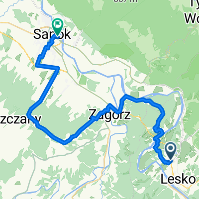
<p>Day 3 of the tour '<strong>Around Solina</strong>'</p>
<ul>
<li>Starting with breakfast at <strong>Zielony Domki</strong>, then through a busy road all the way to <em>Sanok</em></li>
<li>In <em>Sanok</em>, turn after Kaufland, where there aren't any Sanok yoghurts, heading towards <em>Trepcza</em></li>
<li>Continue riding through the valley of the <em>San</em>, meaning flat, even, and pleasant terrain.</li>
<li>Near the village of <em>Dobra</em>, the asphalt ends on this side of the river (you can possibly ride through the forest towards <em>Witryłów</em>, but you should ask the locals) and cross the bridge.</li>
<li>Through <em>Ulucz</em>, we ride on remnants of asphalt and then a stretch on a hardened road to <em>Jabłonica Ruska</em></li>
<li>Ferry crossing to <em>Krzemienica</em> and then straight on the main road to <em>Dynów</em></li>
<li>From <em>Dynów</em>, main road through <em>Szklary</em> and usually route number 878, but you can choose the route via <em>Harta, Błażowa and Borek</em></li>
<li></li>
</ul>
Translated, show original (Polish)- -:--
- Duration
- 99.2 km
- Distance
- 654 m
- Ascent
- 757 m
- Descent
- ---
- Avg. speed
- 388 m
- Max. altitude

Route quality
Waytypes & surfaces along the route
Waytypes
Road
28.8 km
(29 %)
Quiet road
6.9 km
(7 %)
Surfaces
Paved
90.3 km
(91 %)
Unpaved
1 km
(1 %)
Asphalt
89.3 km
(90 %)
Paved (undefined)
1 km
(1 %)
Continue with Bikemap
Use, edit, or download this cycling route
You would like to ride 3/3 Dookoła Soliny or customize it for your own trip? Here is what you can do with this Bikemap route:
Free features
- Save this route as favorite or in collections
- Copy & plan your own version of this route
- Split it into stages to create a multi-day tour
- Sync your route with Garmin or Wahoo
Premium features
Free trial for 3 days, or one-time payment. More about Bikemap Premium.
- Navigate this route on iOS & Android
- Export a GPX / KML file of this route
- Create your custom printout (try it for free)
- Download this route for offline navigation
Discover more Premium features.
Get Bikemap PremiumFrom our community
Other popular routes starting in Lesko
 Velo San Lesko - Malinki - Zasław - Kąty - Sanok
- Distance
- 28.1 km
- Ascent
- 411 m
- Descent
- 448 m
- Location
- Lesko, Subcarpathian Voivodeship, Poland
 Lesko-Tarnawa Górna-Zagórz-Lesko
- Distance
- 21 km
- Ascent
- 345 m
- Descent
- 342 m
- Location
- Lesko, Subcarpathian Voivodeship, Poland
 Lesko-Bóbrka-Myczkowce-Lesko
- Distance
- 27.3 km
- Ascent
- 399 m
- Descent
- 408 m
- Location
- Lesko, Subcarpathian Voivodeship, Poland
 Wielka Pętla Bieszczadzka
- Distance
- 151.8 km
- Ascent
- 2,107 m
- Descent
- 2,105 m
- Location
- Lesko, Subcarpathian Voivodeship, Poland
 5A "wzgórze gruszka"
- Distance
- 44.3 km
- Ascent
- 429 m
- Descent
- 451 m
- Location
- Lesko, Subcarpathian Voivodeship, Poland
 bieszczady 2015 kmikazze
- Distance
- 149.4 km
- Ascent
- 1,360 m
- Descent
- 1,362 m
- Location
- Lesko, Subcarpathian Voivodeship, Poland
 wersja 2 mapa nie puszcza przez zapore
- Distance
- 138.1 km
- Ascent
- 1,252 m
- Descent
- 1,259 m
- Location
- Lesko, Subcarpathian Voivodeship, Poland
 Mała Pętla Bieszczadzka
- Distance
- 95.6 km
- Ascent
- 911 m
- Descent
- 911 m
- Location
- Lesko, Subcarpathian Voivodeship, Poland
Open it in the app