

Zalesie-Kraczkowa-Albigowa-Borówki-Chmielnik
A cycling route starting in Tyczyn, Subcarpathian Voivodeship, Poland.
Overview
About this route
Krótka trasa z długimi płaskimi odcinkami jak i kilkoma podjazdami.
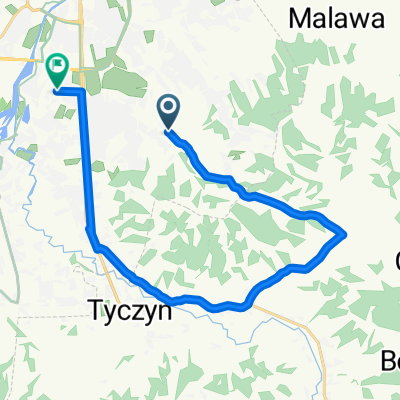
Start Zalesie, dojazd do Słociny
Szybki i płaski odcinek przez Malawę i Kraczkową. Postój w Albigowej.
Tu zaczyna się długi, wredny podjazd.
W Zabratówce zjazd "na pysk" i 70-80km/h do osiągnięcia w zależności od wiatru.
Po czym zaczyna sie kolejny podjazd ;)
Skręt na Borówki, z uwagą, że tam jest fatalny asfalt i przez 5 km jedzie się wyboistą dziurawą drogą.
Skręt na Chmielnik i długi zjazd.
Z Chmielnika ostro do góry do Matysówki, gdzie czeka kolejny wesoły zjazd badający naszą odwagę sprawność hamulców :)
- -:--
- Duration
- 49.3 km
- Distance
- 492 m
- Ascent
- 465 m
- Descent
- ---
- Avg. speed
- 385 m
- Max. altitude

Route quality
Waytypes & surfaces along the route
Waytypes
Road
29.5 km
(60 %)
Busy road
9 km
(18 %)
Surfaces
Paved
39.5 km
(80 %)
Asphalt
39.5 km
(80 %)
Undefined
9.8 km
(20 %)
Continue with Bikemap
Use, edit, or download this cycling route
You would like to ride Zalesie-Kraczkowa-Albigowa-Borówki-Chmielnik or customize it for your own trip? Here is what you can do with this Bikemap route:
Free features
- Save this route as favorite or in collections
- Copy & plan your own version of this route
- Sync your route with Garmin or Wahoo
Premium features
Free trial for 3 days, or one-time payment. More about Bikemap Premium.
- Navigate this route on iOS & Android
- Export a GPX / KML file of this route
- Create your custom printout (try it for free)
- Download this route for offline navigation
Discover more Premium features.
Get Bikemap PremiumFrom our community
Other popular routes starting in Tyczyn
 Zalesie-Dylągówka-Bachórz-Łańcut-Zaczernie
- Distance
- 98.9 km
- Ascent
- 955 m
- Descent
- 993 m
- Location
- Tyczyn, Subcarpathian Voivodeship, Poland
 Matysówka nocą
- Distance
- 21.6 km
- Ascent
- 422 m
- Descent
- 417 m
- Location
- Tyczyn, Subcarpathian Voivodeship, Poland
 Odkrywając nowe asfalty wokół Rzeszowa CLONED FROM ROUTE 440448
- Distance
- 113.4 km
- Ascent
- 976 m
- Descent
- 1,095 m
- Location
- Tyczyn, Subcarpathian Voivodeship, Poland
 Krótsza trasa przez Tyczyn
- Distance
- 18.3 km
- Ascent
- 209 m
- Descent
- 209 m
- Location
- Tyczyn, Subcarpathian Voivodeship, Poland
 Na wschód od Rzeszowa
- Distance
- 100.6 km
- Ascent
- 632 m
- Descent
- 629 m
- Location
- Tyczyn, Subcarpathian Voivodeship, Poland
 Wielka Pętla wokół Rzeszowa
- Distance
- 159.2 km
- Ascent
- 846 m
- Descent
- 853 m
- Location
- Tyczyn, Subcarpathian Voivodeship, Poland
 Niedzielna trasa v1
- Distance
- 11.5 km
- Ascent
- 77 m
- Descent
- 77 m
- Location
- Tyczyn, Subcarpathian Voivodeship, Poland
 4A, Matysówka do Zaciszna 5, Rzeszów
- Distance
- 16.9 km
- Ascent
- 124 m
- Descent
- 160 m
- Location
- Tyczyn, Subcarpathian Voivodeship, Poland
Open it in the app